JPL
Careers
Education
Science & Technology
JPL Logo
JPL Logo
Image

Surface Flooding from Hurricane Harvey Shown in New SMAP Imagery
Aug 30, 2017
A new series of images generated with data from NASA's Soil Moisture Active Passive (SMAP) satellite illustrate the surface flooding caused by Hurricane Harvey from before its initial landfall through August 27, 2017.

click here for larger version of figure 1 for PIA21930
Aug. 22, 2017
click here for larger version of figure 2 for PIA21930
Aug. 27, 2017
click here for larger version of figure 3 for PIA21930
Aug. 22-27, 2017
Click on images for larger versions

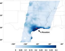
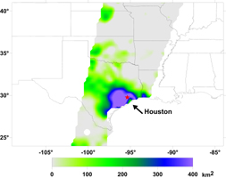
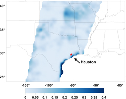
A new series of images generated with data from NASA's Soil Moisture Active Passive (SMAP) satellite illustrate the surface flooding caused by Hurricane Harvey from before its initial landfall through August 27, 2017. The SMAP observations detect the proportion of the ground covered by surface water within the satellite's field of view. The sequence of images depicts successive satellite orbital swath observations showing the surface water conditions on August 22, before Harvey's landfall (left), and then on Aug. 27, two days after landfall (middle). The resulting increase in surface flooding from record rainfall over the three-day period, shown at right, depicts regionally heavy flooding around the Houston metropolitan area. The hardest hit areas (blue and purple shades) cover more than 23,000 square miles (about 59,600 square kilometers) and indicate a more than 1,000-fold increase in surface water cover from rainfall-driven flooding. SMAP's low-frequency (L-band) microwave radiometer features enhanced capabilities for detecting surface water changes in nearly all weather conditions and under low-to-moderate vegetation cover. The satellite provides global coverage with one to three-day repeat sampling, which is well suited for monitoring dynamic inland waters around the world.

SMAP is managed for NASA's Science Mission Directorate in Washington by NASA's Jet Propulsion Laboratory in Pasadena, California, and NASA's Goddard Space Flight Center in Greenbelt, Maryland. JPL is managed for NASA by Caltech. A consortium of researchers from other universities participate on the SMAP science team, including the Massachusetts Institute of Technology in Cambridge; Princeton University in Princeton, New Jersey; and the University of Montana in Missoula, which provided the SMAP surface water imagery.

For more information about SMAP, visit http://smap.jpl.nasa.gov.

Download JPG
Download TIFF
Mission
  • Soil Moisture Active Passive
Target
  • Earth
Credit
NASA/JPL-Caltech/GSFC/University of Montana

Keep Exploring

SMAP Sea Surface Salinity and Soil Moisture Time Lapse

NASA's SMAP Detects Flooding from Hurricane Michael

Hurricane Michael as seen by SMAP

SMAP Captures Hurricane Michael

Hurricane Florence seen by SMAP Imagery

Hurricane Maria's Strengthening Winds Seen in NASA SMAP Image

New NASA Maps Show Flooding Changes In Aftermath of Hurricane Harvey

Rapid Intensification of Hurricane Irma Seen in New SMAP Wind Images

NASA SMAP Images Show Texas Soil Moisture Conditions Before/After Hurricane Harvey's Landfall

Hurricane Harvey's Rapid Wind Intensification seen by NASA's SMAP

Related Topic

News .

Warming Seas Are Accelerating Greenland’s Glacier Retreat

Topic .

Earth

Infographic .

Inside Hurrricanes

News .

NASA, US and European Partner Satellite Returns First Sea Level Measurements

News .

NASA Confirms New SIMPLEx Mission Small Satellite to Blaze Trails Studying Lunar Surface

News .

New Data Confirm 2020 SO to Be the Upper Centaur Rocket Booster From the 1960's

News .

Follow Sentinel-6 Michael Freilich in Real Time As It Orbits Earth

News .

US-European Mission Launches to Monitor the World's Oceans

Video .

NASA and SpaceX Launch U.S.-European Mission to Monitor World’s Ocean

News .

Sentinel-6 Michael Freilich Satellite Prepared for Launch

About JPL
Who We Are
Executive Council
Directors of JPL
JPL History
Documentary Series
Virtual Tour
Annual Reports
Missions
All
Current
Past
Future
News
All
Earth
Mars
Solar System
Universe
Technology
Galleries
Images
Videos
Audio
Podcasts
Infographics
Engage
JPL and the Community
Lecture Series
Public Tours
Events
Team Competitions
JPL Speakers Bureau
Topics
Solar System
Mars
Earth
Climate Change
Stars and Galaxies
Exoplanets
Technology
JPL Life
For Media
Contacts and Information
Press Kits
More
Asteroid Watch
Robotics at JPL
Subscribe to Newsletter
Social Media
Get the Latest from JPL
Follow Us

JPL is a federally funded research and development center managed for NASA by Caltech.

More from JPL
Careers Education Science & Technology Acquisitions JPL Store
Careers
Education
Science & Technology
Acquisitions
JPL Store
Related NASA Sites
Basics of Spaceflight
Climate Kids
Earth / Global Climate Change
Exoplanet Exploration
Mars Exploration
Solar System Exploration
Space Place
NASA's Eyes Visualization Project
Voyager Interstellar Mission
NASA
Caltech
Privacy
Image Policy
FAQ
Feedback
Site Manager: Veronica McGregor
Site Editors: Tony Greicius, Randal Jackson, Naomi Hartono