NASA SMAP Images Show Texas Soil Moisture Conditions Before/After Hurricane Harvey's Landfall
 |  |
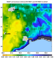
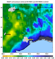
| August 21/22 | August 25/26 |
Images of soil moisture conditions in Texas near Houston, generated by NASA's Soil Moisture Active Passive (SMAP) satellite before and after the landfall of Hurricane Harvey can be used to monitor changing ground conditions due to Harvey's rainfall. As seen in the left panel, SMAP observations show that soil surface conditions were already very wet a few days before the hurricane made landfall (August 21/22), with moisture levels in the 20 to 40 percent range. Such saturated soil surfaces contributed to the inability of water to infiltrate more deeply into soils, thereby increasing the likelihood of flooding. After Harvey made landfall, the southwest portion of Houston became exceptionally wet, as seen in the right panel image from August 25/26, signaling the arrival of heavy rains and widespread flooding.
SMAP is managed for NASA's Science Mission Directorate in Washington by NASA's Jet Propulsion Laboratory in Pasadena, California, with participation by NASA's Goddard Space Flight Center in Greenbelt, Maryland. JPL is responsible for project management, system engineering, instrument management, the radar instrument, mission operations and the ground data system. Goddard is responsible for the radiometer instrument. Both centers collaborate on the science data processing and delivery of science data products to the Alaska Satellite Facility and the National Snow and Ice Data Center for public distribution and archiving. JPL is managed for NASA by Caltech.
For more information about SMAP, visit http://smap.jpl.nasa.gov.
