JPL
Careers
Education
Science & Technology
JPL Logo
JPL Logo
Image

Rapid Intensification of Hurricane Irma Seen in New SMAP Wind Images

Jet Propulsion Laboratory https://www.jpl.nasa.gov/ Sept. 5, 2017
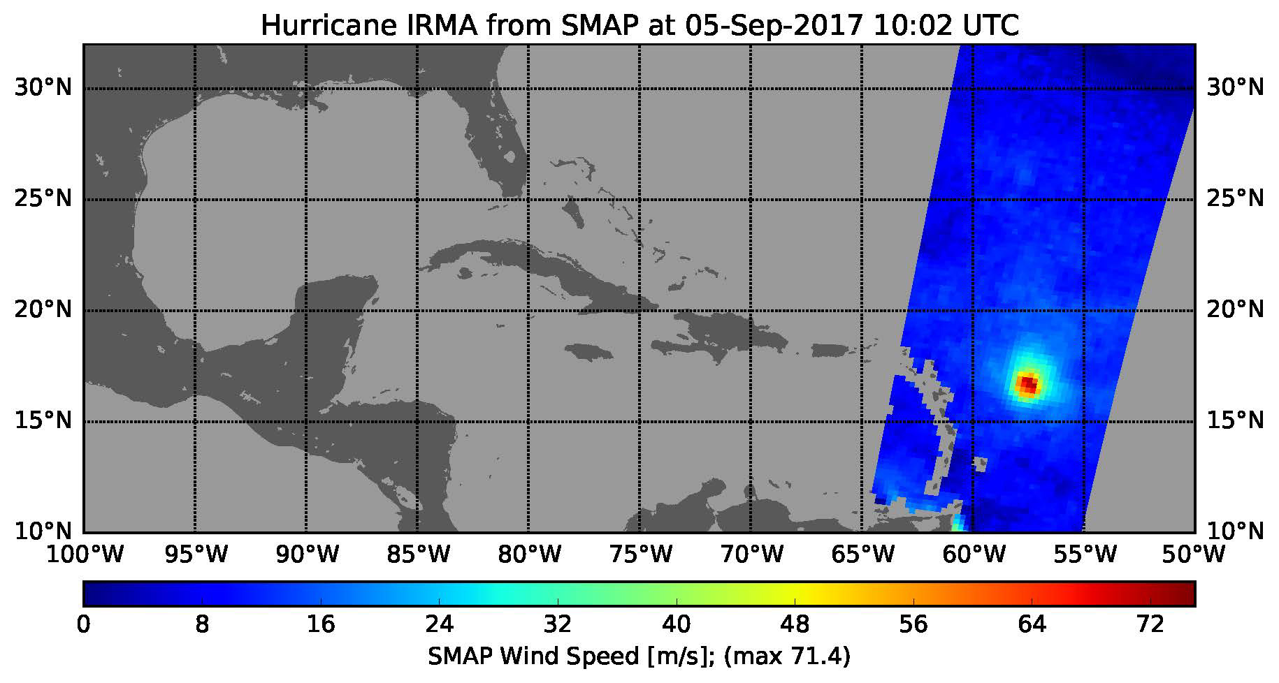
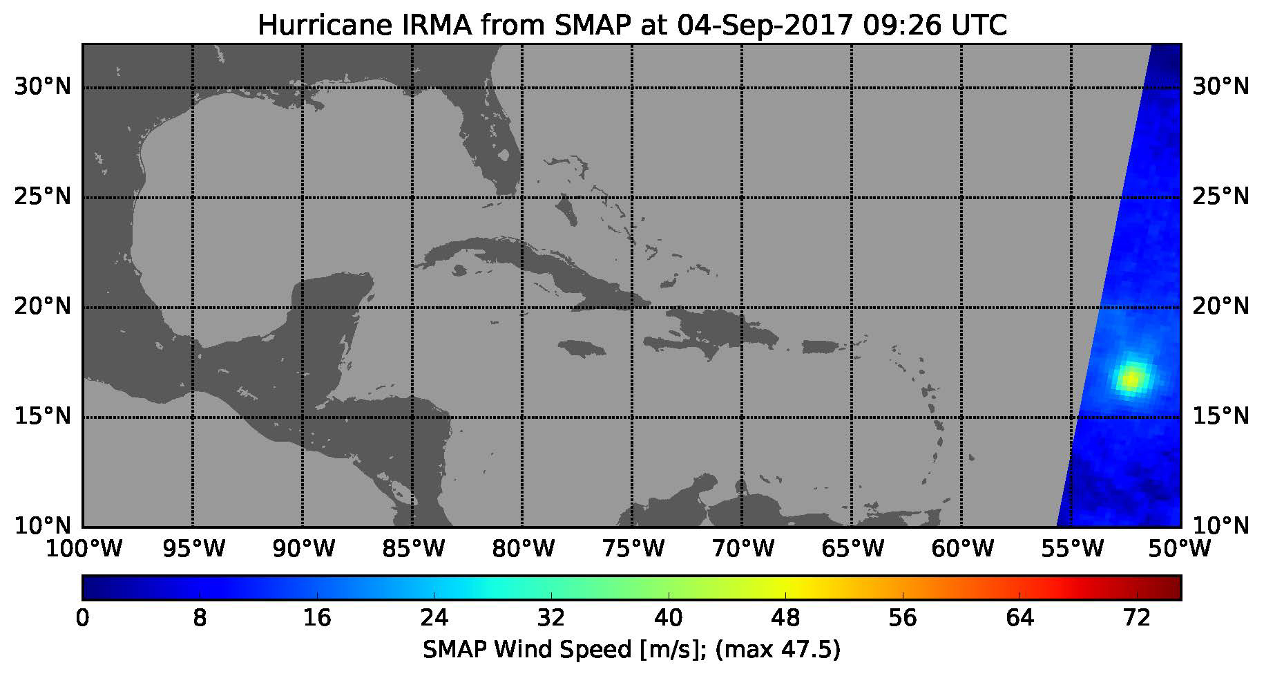
This pair of images shows ocean surface wind speeds for Hurricane Irma as observed Sept. 4, 2017 (top) and 24.5 hours later at 6:02 a.m. EDT on September 5th (bottom) by the radiometer instrument on NASA's Soil Moisture Active SMAP satellite.

click here for Figure 1 for PIA21939click here for Figure 2 for PIA21939
Sept. 4, 2017Sept. 5, 2017
Click on an individual image for the larger version

This pair of images shows ocean surface wind speeds for Hurricane Irma as observed at 5:26 a.m. EDT on Sept. 4, 2017 (top) and 24.5 hours later at 6:02 a.m. EDT on September 5th (bottom) by the radiometer instrument on NASA's Soil Moisture Active Passive (SMAP) satellite. Color indicates wind speed, with red being highest and blue lowest. Irma intensified from a Category 2 hurricane on Sept. 4 with observed wind speed of 106 miles per hour (47.5 meters per second) to a Category 5 hurricane on Sept. 5 with a maximum observed wind speed of 160 miles per hour (71.4 meters per second).

SMAP is managed for NASA's Science Mission Directorate in Washington by NASA's Jet Propulsion Laboratory in Pasadena, California, with participation by NASA's Goddard Space Flight Center in Greenbelt, Maryland. JPL is responsible for project management, system engineering, instrument management, the radar instrument, mission operations and the ground data system. Goddard is responsible for the radiometer instrument. Both centers collaborate on the science data processing and delivery of science data products to the Alaska Satellite Facility and the National Snow and Ice Data Center for public distribution and archiving. JPL is managed for NASA by Caltech.

For more information about SMAP, visit http://smap.jpl.nasa.gov.

Download JPG
Download TIFF
Mission
Target
  • Earth
Credit
NASA/JPL-Caltech/GSFC

Keep Exploring

SMAP Sea Surface Salinity and Soil Moisture Time Lapse

NASA's SMAP Detects Flooding from Hurricane Michael

Hurricane Michael as seen by SMAP

SMAP Captures Hurricane Michael

Hurricane Florence seen by SMAP Imagery

Hurricane Maria's Strengthening Winds Seen in NASA SMAP Image

New NASA Maps Show Flooding Changes In Aftermath of Hurricane Harvey

Surface Flooding from Hurricane Harvey Shown in New SMAP Imagery

NASA SMAP Images Show Texas Soil Moisture Conditions Before/After Hurricane Harvey's Landfall

Hurricane Harvey's Rapid Wind Intensification seen by NASA's SMAP

About JPL
Who We Are
Directors
Careers
Internships
The JPL Story
JPL Achievements
Documentary Series
JPL Annual Report
Executive Council
Missions
Current
Past
Future
All
News
All
Earth
Solar System
Stars and Galaxies
Eyes on the News
Subscribe to JPL News
Galleries
Images
Videos
Audio
Podcasts
Apps
Visions of the Future
Slice of History
Robotics at JPL
Events
Lecture Series
Speakers Bureau
Calendar
Visit
Public Tours
Virtual Tour
Directions and Maps
Topics
JPL Life
Solar System
Mars
Earth
Climate Change
Exoplanets
Stars and Galaxies
Robotics
More
Asteroid Watch
NASA's Eyes Visualizations
Universe - Internal Newsletter
Social Media
Accessibility at NASA
Contact Us
Get the Latest from JPL
Follow Us

JPL is a federally funded research and development center managed for NASA by Caltech.

More from JPL
Careers
Education
Science & Technology
Acquisition
JPL Store
Careers
Education
Science & Technology
Acquisition
JPL Store
Related NASA Sites
Basics of Spaceflight
NASA Kids Science - Earth
Earth / Global Climate Change
Exoplanet Exploration
Mars Exploration
Solar System Exploration
Space Place
NASA's Eyes Visualization Project
Voyager Interstellar Mission
NASA
Caltech
Privacy
Image Policy
FAQ
Feedback
Version: v3.1.3 - 5e83a9a
Site Managers:Emilee Richardson, Alicia Cermak
Site Editors:Naomi Hartono, Steve Carney
CL#:21-0018