JPL
Careers
Education
Science & Technology
JPL Logo
JPL Logo
Earth
.

NASA's ECOSTRESS Maps European Heat Wave From Space

Jul 02, 2019
These maps of four European cities show ECOSTRESS surface temperature images acquired in the early mornings of June 27 and 28, 2019, during a heatwave. The images have been sharpened to delineate key features such as airports. Airports and city centers are hotter than surrounding regions because they have more surfaces that retain heat (asphalt, concrete, etc.).
Credit: NASA/JPL-Caltech

The mission aboard the space station imaged four European cities during a heat wave that sent temperatures soaring above 104 degrees Fahrenheit (40 degrees Celsius).

Europe's massive heat wave is on its way out - and it's leaving a slew of broken temperature records in its wake. Many countries were gripped by temperatures above 104 Fahrenheit (40 degrees Celsius) between June 26 and June 30. According to the World Meteorological Organization, June 2019 is now the hottest month on record for the continent as a whole.

NASA's Ecosystem Spaceborne Thermal Radiometer Experiment on Space Station (ECOSTRESS) measures Earth's surface temperature from the International Space Station at different times of day. Although its primary objective is to monitor the health of plants, ECOSTRESS can also detect heat events such as the one much of Europe just experienced.

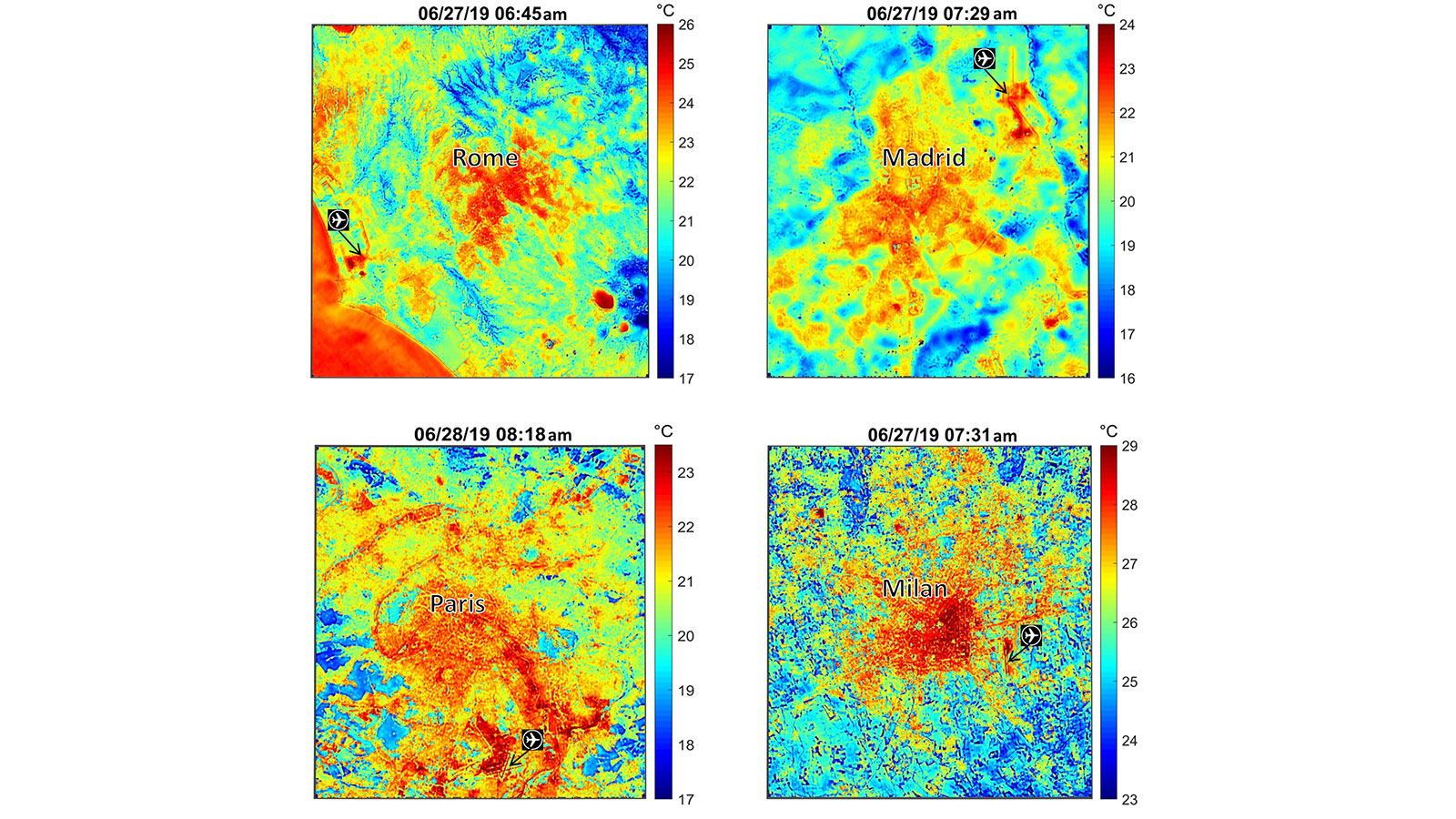
ECOSTRESS mapped the surface, or ground temperature, of four European cities - Rome, Paris, Madrid and Milan - during the mornings of June 27 and June 28.In the images, hotter temperatures appear in red and cooler temperatures appear in blue. They show how the central core of each city is much hotter than the surrounding natural landscape due to the urban heat island effect - a result of urban surfaces storing and re-radiating heat throughout the day.

The fact that surface temperatures were as high as 77-86 degrees Fahrenheit (25-30 degrees Celsius) in the early morning indicates that much of the heat from previous days was stored by surfaces with high heat capacity (such as asphalt, concrete and water bodies) and unable to dissipate before the next day. The trapped heat resulted in even higher midday temperatures, in the high 40s (Celsius) in some places, as the heat wave continued.

ECOSTRESS launched to the space station last summer and began collecting its first heat data just days after installation. The instrument measures variations of ground temperatures to within a few tenths of a degree, and it does so with unprecedented detail: It's able to detect temperature changes at various times of day over areas the size of a football field. These measurements help scientists assess plant health and response to water shortages, which can be an indicator of future drought. They can also be used in observing heat trends, spotting wildfires and detecting volcanic activity.

ECOSTRESS provides a wide range of image products for studying the land surface and recently made all these products publicly available through the NASA Land Processes Distributed Active Archive Center (LPDAAC).

JPL built and manages the ECOSTRESS mission for NASA's Earth Science Division in the Science Mission Directorate at NASA Headquarters in Washington. ECOSTRESS is an Earth Venture Instrument mission; the program is managed by NASA's Earth System Science Pathfinder program at NASA's Langley Research Center in Hampton, Virginia.

For more information on ECOSTRESS visit:

https://ecostress.jpl.nasa.gov

For more information on Earth science activities aboard the International Space Station, visit:

http://www.nasa.gov/issearthscience

News Media Contact

Esprit Smith

818-354-4269

Esprit.Smith@jpl.nasa.gov

2019-134

Related News

Weather .

A Pioneering NASA Mini Weather Satellite Ends Its Mission

Climate Change .

NASA Satellites Help Quantify Forests’ Impacts on the Global Carbon Budget

Mars .

NASA’s Perseverance Pays Off Back Home

Climate Change .

Warming Seas Are Accelerating Greenland’s Glacier Retreat

Earth .

NASA, US and European Partner Satellite Returns First Sea Level Measurements

Technology .

NASA Confirms New SIMPLEx Mission Small Satellite to Blaze Trails Studying Lunar Surface

Earth .

New Data Confirm 2020 SO to Be the Upper Centaur Rocket Booster From the 1960's

Earth .

Follow Sentinel-6 Michael Freilich in Real Time As It Orbits Earth

Climate Change .

US-European Mission Launches to Monitor the World's Oceans

Climate Change .

Sentinel-6 Michael Freilich Satellite Prepared for Launch

Explore More

Image .

Tumbiana Stromatolite

Image .

Banjul, The Gambia

Image .

Lake Salda Beach

Image .

Lake Salda Rocks

Image .

Serabit el-Khadim, Egypt

Image .

Glacier Undercutting in Action

Image .

Hulhumale, Maldives

Topic .

Earth

Image .

Kilauea Volcano, Hawaii

Infographic .

Inside Hurrricanes

About JPL
Who We Are
Executive Council
Directors of JPL
JPL History
Documentary Series
Virtual Tour
Annual Reports
Missions
All
Current
Past
Future
News
All
Earth
Mars
Solar System
Universe
Technology
Galleries
Images
Videos
Audio
Podcasts
Infographics
Engage
JPL and the Community
Lecture Series
Public Tours
Events
Team Competitions
JPL Speakers Bureau
Topics
Solar System
Mars
Earth
Climate Change
Stars and Galaxies
Exoplanets
Technology
JPL Life
For Media
Contacts and Information
Press Kits
More
Asteroid Watch
Robotics at JPL
Subscribe to Newsletter
Universe Newsletter
Social Media
Get the Latest from JPL
Follow Us

JPL is a federally funded research and development center managed for NASA by Caltech.

More from JPL
Careers Education Science & Technology Acquisitions JPL Store
Careers
Education
Science & Technology
Acquisitions
JPL Store
Related NASA Sites
Basics of Spaceflight
Climate Kids
Earth / Global Climate Change
Exoplanet Exploration
Mars Exploration
Solar System Exploration
Space Place
NASA's Eyes Visualization Project
Voyager Interstellar Mission
NASA
Caltech
Privacy
Image Policy
FAQ
Feedback
Site Manager: Veronica McGregor
Site Editors: Tony Greicius, Randal Jackson, Naomi Hartono