NISAR Press Kit
Our home planet is constantly changing in a variety of ways — some subtle, others dramatic. The NISAR mission will enable us to comprehensively monitor Earth’s land and ice surfaces, building a detailed record of large and small changes over time.
Short for NASA-ISRO Synthetic Aperture Radar, NISAR will help scientists better understand processes involved in natural hazards and catastrophic events, such as earthquakes, volcanic eruptions, and landslides. The NISAR satellite’s cloud-penetrating ability will help the urgent-response communities during weather disasters such as hurricanes, storm surge, and flooding. It will also provide key global Earth observations such as changes in ice sheets, glaciers, and sea ice, as well as improve understanding of how deforestation, permafrost loss, and fires affect the carbon cycle.
A collaboration between NASA and the Indian Space Research Organisation (ISRO), NISAR is targeted for launch on July 30, 2025. The mission will lift off from Satish Dhawan Space Centre in Sriharikota, on India’s southeastern coast.
5 Things to Know About NISAR
A trailblazing mission, NISAR will provide a trove of scientific information about Earth’s processes, gathering unprecedented amounts of data. The mission has also broken new ground with its collaboration between teams of scientists and engineers separated by more than 9,000 miles and 13 time zones. Here are five key things to know about this ambitious mission and its wide-reaching goals:
1. The mission will study key changes in Earth’s land and ice.
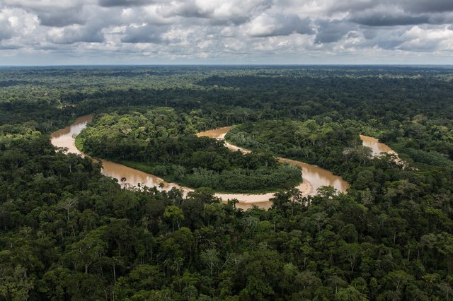
Amazon rainforest. Credit: USDA | Full Image
The NISAR mission capitalizes on the capabilities of synthetic aperture radar to study Earth’s land and ice. The system works by transmitting microwave signals to Earth and then receiving the signals reflected from the surface below, in this case via a massive 39-foot (12-meter) radar antenna reflector that resembles a massive snare drum. By interpreting the ways in which the surface has altered the return signal compared to what was transmitted, researchers can discern physical characteristics about the surface. Then, by passing over the same locations on the planet twice every 12 days, they can determine how those characteristics have changed over time. And unlike optical sensors, NISAR will be able to “see” through clouds and light rain, as well as in darkness and light.
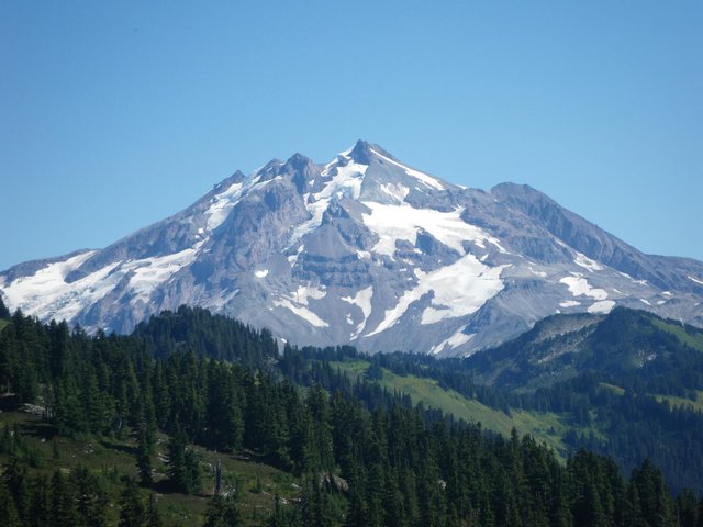
Glacier Peak volcano, Washington. Credit: USGS | Full Image
The mission will use these capabilities to address a variety of science questions, among them: How much carbon are the Amazon and Congo rainforests holding, and how are these important forests changing over time? How fast are mountain glaciers advancing or retreating, and how will melting glaciers affect water supplies and flooding for downstream populations? What miniscule changes can be seen in Earth’s crust before and after an earthquake, volcanic eruption, or other natural disaster, and how could that information help assess the risk and mitigate the impact of disasters?
NISAR: Tracking Earth’s Changes From Space (Mission Overview)
2. The NISAR spacecraft will carry the most advanced radar system ever launched as part of a NASA or ISRO mission.
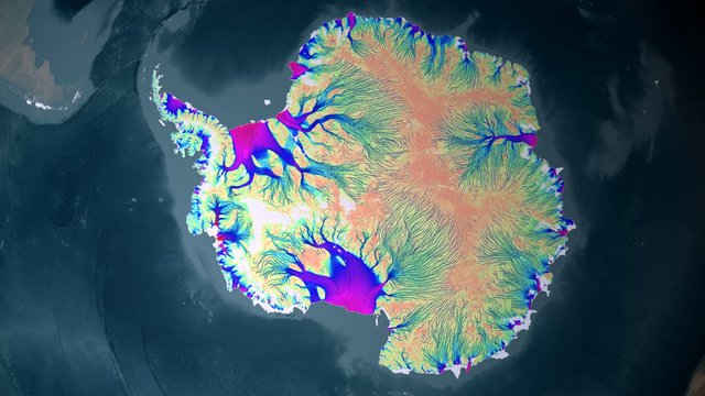
Visualization of Antarctic ice motion. Credit: NASA/GSFC SVS | Full Image
The NISAR mission is more powerful than prior synthetic aperture radar missions, and it will monitor parts of Earth not previously covered. About the length of a pickup truck, the satellite’s main body contains engineering systems and a first-of-its-kind dual-radar payload — an L-band system with a 10-inch (25-centimeter) wavelength and an S-band system with a 4-inch (10-centimeter) wavelength. Each system’s signal is sensitive to different sizes of features on Earth’s surface, and each specializes in measuring different attributes, such as moisture content, surface roughness, and motion. These characteristics are important for studying a variety of natural surface conditions, such as the amount of soil moisture available for vegetation to thrive or if permafrost has thawed.
When operating together, the two radars will collect data synchronized in time and location, extending the sensitivity of the measurements to objects on the surface in a broad range of sizes. For example, S-band data will allow more accurate characterization of shorter plants, such as bushes and shrubs, while L-band data will sense taller vegetation, like trees. NISAR will operate in a Sun-synchronous orbit, with its radar antennas pointed in a configuration that will also offer unprecedented coverage of Antarctica. This is crucial for studying the motion, deformation, and melting of the Antarctic ice sheet as it breaks up and melts into the ocean.
3. The spacecraft’s two radars will produce the most data ever generated on a daily basis by a NASA or ISRO Earth mission.
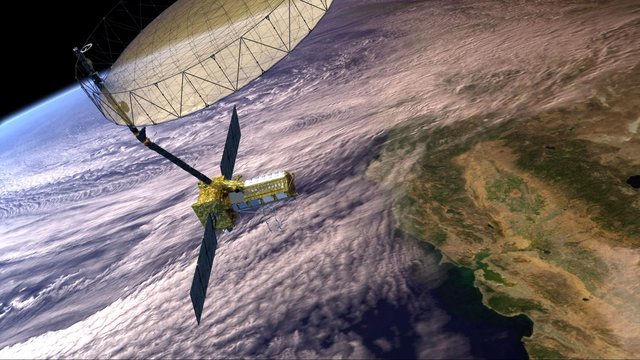
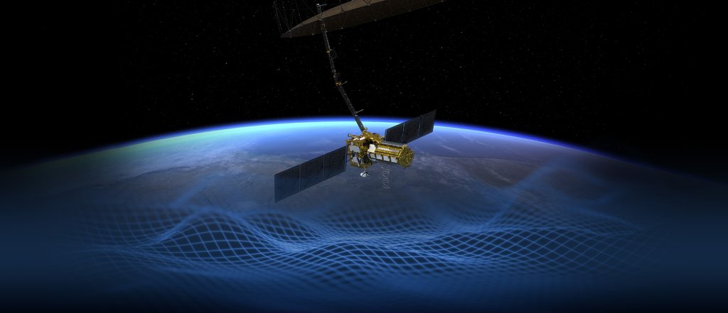
Artist’s concept of NISAR in orbit over California. Credit: NASA/JPL-Caltech | Full Image
The two radars aboard the spacecraft will generate about 100 petabytes of data products over the course of NISAR’s three-year prime mission, or about 80 terabytes per day. That’s about enough data to fill about 150 512-gigabyte hard drives in a day. Due to the sheer volume of information that the satellite will transmit to Earth, NISAR’s data will be processed, stored, and distributed via the cloud. It will be available for anyone to use, free of charge, in keeping with NASA open-science principles. All S-band and L-band data will also be available to Indian government users through ISRO’s National Remote Sensing Centre.
4. The mission belongs to a long line of Earth-observing SAR instruments and will contribute to NASA’s and ISRO’s legacy of studying our home planet.

Visualization of Earth’s Eastern Hemisphere. Credit: NASA/Reto Stöckli, based on NASA and NOAA data | Full Image
NASA’s Seasat, developed at the agency’s Jet Propulsion Laboratory in Southern California and launched in 1978, was the first-ever spaceborne synthetic aperture radar instrument used for science observations. Since then a series of these systems has operated on aircraft and in space, studying Earth’s surface to advance studies in an array of science areas.
Similarly, ISRO launched a series of synthetic aperture radar missions, including Radar Imaging Satellite (RISAT-1) in 2012 and RISAT-1A in 2022, to support a wide range of applications in India. The NISAR mission will provide continuity of data, as well as something unique: wide-swath, high-resolution dual-band radar data.
NISAR joins a great observatory of NASA Earth satellites studying our oceans, land, ice, atmosphere, and vegetation to create a dynamic, 3D view of our home planet.
5. This is the first-ever hardware collaboration between NASA and ISRO on an Earth-observing mission.
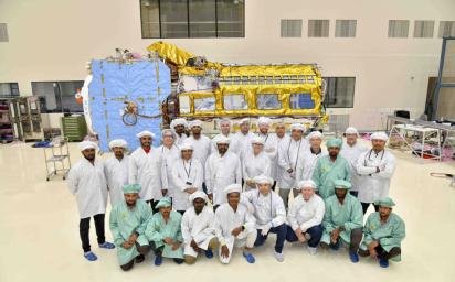
Engineers and technicians from ISRO and NASA JPL pose with the NISAR satellite under assembly in June 2023 at ISRO's U R Rao Satellite Centre in Bengaluru, India. Credit: VDOS-URSC | Full Image
The idea for NISAR originated with the 2007 National Academy of Sciences decadal survey, which identified the need for greater insight into ecosystems, solid Earth, and cryosphere sciences. In subsequent years, ISRO and NASA began discussing the potential of a joint, dual-frequency radar mission to address each agency’s Earth science priorities, and in 2014 they signed an agreement to collaborate on NISAR.
NISAR features components developed on opposite sides of the planet by ISRO and NASA JPL engineers working together, even through a global pandemic. The S-band radar was built at ISRO’s Space Applications Centre in Ahmedabad and transported in March 2021 to JPL, which had been building the L-band radar. For the next two years, JPL and ISRO engineers integrated and tested the two systems, and in March 2023, the combined instrument payload made the journey to ISRO’s Satellite Integration & Testing Establishment facility in the southern Indian city of Bengaluru.
After integration with a modified ISRO I3K spacecraft bus and rigorous testing, the satellite was transported to Satish Dhawan Space Centre on India’s southeastern coast. It is set to launch aboard an ISRO Geosynchronous Satellite Launch Vehicle rocket. The ISRO Telemetry, Tracking and Command Network facility in Bengaluru and JPL’s Earth Orbiting Missions Operations Center will manage satellite operations based on the requirements provided by a team of NASA and ISRO scientists.
Download the Press Kit