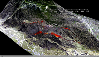
Esperanza Wildfire Animation

Click on the image for the video
This animation is a visualization of the rapid advance of the Esperanza Fire over the San Jacinto Mountains (Riverside County, CA) between 11:00 AM and 7:00 PM on October 26, 2006. The animation was generated from maps of fire temperature as measured by the U.S. Forest Service. The yellow, orange, and red colors signify temperatures of 400, 200, and 75 C, respectively. The data for the temperature maps were acquired with the FireMapper™, an airborne imaging instrument operated by the USFS Pacific Southwest Research Station.
Starting with five temperature maps, image-morphing techniques were applied to approximate the shape and position of the fire at 10-second intervals over the 7-hour period of observation. The morphed images were superimposed over a digital elevation model (DEM) and rendered as 3-D perspective views for the animation. Ground conditions are represented before and after the fire with a pair of ASTER satellite images.
The Esperanza Fire began at 1:15 on the morning of October 26, 2006, when an arsonist started a fire in a river wash on the outskirts of Cabazon. Within one day the fire spread to more than 19,000 acres, and flames reached heights of 90 feet and moved at speeds of up to 40 mph. The fire was 100% contained on October 30, after burning more than 40,200 acres and destroying 34 homes and 20 outbuildings. The estimated cost of fighting this fire was over nine million dollars.
For more information regarding this animation, please contact Vincent Realmuto, Jet Propulsion Laboratory.
