Eyjafjallajökull Ash Continues to Disrupt Air Traffic

Figure 1
Click on the image for larger version
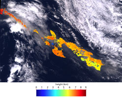
Ash from Iceland's Eyjafjallajökull volcano, viewed here in imagery from the Multi-angle Imaging SpectroRadiometer (MISR) instrument on NASA's Terra spacecraft on May 16, 2010, once again disrupted air traffic over Europe with the closure of major airports in the United Kingdom and the Netherlands. The image is a natural-color, nadir (vertical) view of the scene, with the volcano itself located outside the upper left corner of the image. The ash plume is visible as a brownish stream of particles situated above lower-level clouds. Stereoscopic images acquired by MISR's other cameras are used to derive the height of the plume. Figure 1 above shows a color-coded plume height map, which is retrieved at 1.1 kilometer (0.68 mile) horizontal resolution, and with vertical accuracy of about half a kilometer (0.3 miles). Close to the source, the plume reaches altitudes exceeding 8 kilometers (26,247 feet), descending to about 6 kilometers (19,685 feet) about 250 kilometers (155 miles) downwind. These heights exceed the values observed by MISR about a week earlier.
The images cover an area measuring 275 by 186 kilometers (171 by 116 miles).
MISR was built and is managed by NASA's Jet Propulsion Laboratory, Pasadena, Calif., for NASA's Office of Earth Science, Washington, D.C. The Terra satellite is managed by NASA's Goddard Space Flight Center, Greenbelt, Md. The MISR data were obtained from the NASA Langley Research Center Atmospheric Science Data Center. JPL is a division of the California Institute of Technology.
