Hurricane Isadore
 |  |
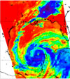
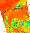
| Figure 1: AIRS channel 2333 (2616 cm-1) | Figure 2: HSB channel 2 (150 GHz) |
Three different views of Hurricane Isidore from the Atmospheric Infrared Sounding System (AIRS) on Aqua.
At the time Aqua passed over Isidore, it was classified as a Category 3 (possibly 4) hurricane, with minimum pressure of 934 mbar, maximum sustained wind speeds of 110 knots (gusting to 135) and an eye diameter of 20 nautical miles. Isidore was later downgraded to a Tropical Storm before gathering strength again.
This is a visible/near-infrared image, made with the AIRS instrument. Its 2 km resolution shows fine details of the cloud structure, and can be used to help interpret the other images. For example, some relatively cloud-free regions in the eye of the hurricane can be distinguished. This image was made with wavelengths slightly different than those seen by the human eye, causing plants to appear very red.
Figure 1 shows high and cold clouds in blue. Figure 2 shows heavy rain cells over Alabama in blue. This image shows the swirling clouds in white and the water of the Gulf of Mexico in blue. The eye of the hurricane is apparent in all three images.
Figure 1 shows how the hurricane looks through an AIRS Infrared window channel. Window channels measure the temperature of the cloud tops or the surface of the Earth in clear regions. The lowest temperatures are over Alabama and are associated with high, cold cloud tops at the end of the cloud band streaming from the hurricane. Although the eye is visible, it does not appear to be completely cloud free.
Figure 2 shows the hurricane as seen through a microwave channel of the Humidity Sounder for Brazil (HSB). This channel is sensitive to humidity, clouds and rain. Unlike the AIRS infrared channel, it can penetrate through cloud layers and therefore reveals some of the internal structure of the hurricane. In this image, the green and yellow colors indicate clouds and heavy moisture, while blue indicates scattering by precipitation in intense convection. Orange indicates warm, moist air near the surface. The ocean surface, could it be seen, would appear slightly colder (yellow to green) due to the relatively low emissivity of water. Three sets of eye walls are apparent, and a number of intense convective cells can also be distinguished.
In the near future, weather data derived from these images will allow us to improve our forecasts and track the paths of hurricanes more accurately. The AIRS sounding system provides 2400 such images, or channels, continuously.
About Airs
The Atmospheric Infrared Sounder, AIRS, in conjunction with the Advanced Microwave Sounding Unit, AMSU, senses emitted infrared and microwave radiation from Earth to provide a three-dimensional look at Earth's weather and climate. Working in tandem, the two instruments make simultaneous observations all the way down to Earth's surface, even in the presence of heavy clouds. With more than 2,000 channels sensing different regions of the atmosphere, the system creates a global, three-dimensional map of atmospheric temperature and humidity, cloud amounts and heights, greenhouse gas concentrations, and many other atmospheric phenomena. The Humidity Sounder for Brazil, HSB, is a 4-channel microwave sounder provided by Brazil that obtained humidity profiles throughout the atmosphere even under conditions of heavy cloudiness and haze. The HSB provided high quality data until February 2003. Launched into Earth orbit in 2002, the AIRS, AMSU, and HSB instruments fly onboard NASA's Aqua spacecraft and are managed by NASA's Jet Propulsion Laboratory in Pasadena, Calif., under contract to NASA. JPL is a division of the California Institute of Technology in Pasadena.More information about AIRS can be found at http://airs.jpl.nasa.gov.
