
The rise in the global mean sea level slowed in 2025 relative to the year before, an effect largely due to the La Niña conditions that persisted over most of the year. According to a NASA analysis, the average height of the ocean increased last year by 0.03 inches (0.08 centimeters), down from 0.23 inches (0.59 centimeters) in 2024.
The 2025 figure also fell below the long-term expected rate of 0.17 inches (0.44 centimeters) per year based on the rate of rise since the early 1990s. Though sea levels have increasingly trended upward in that period, years during which the rise in the average height was less usually have occurred during La Niñas — the part of the El Niño-Southern Oscillation cycle that cools the eastern Pacific Ocean, often leading to heavy rainfall over the equatorial portions of South America.
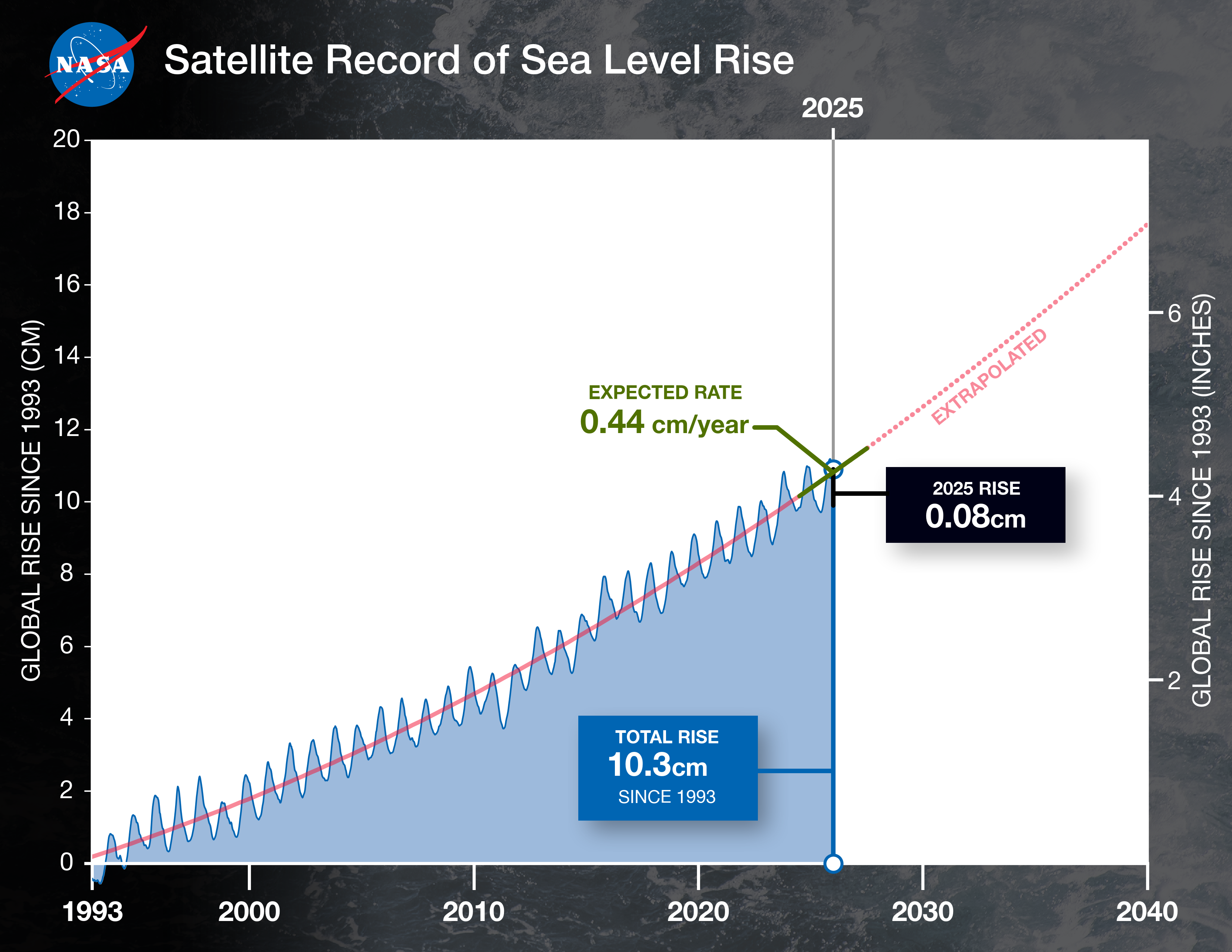
This graph shows the rise in global mean sea level from 1993 to 2025 based on data from a series of five international satellites. The solid red line indicates an accelerating rate of increase, which has more than doubled over three-plus decades. The dotted red line projects future sea level rise.
The current La Niña has been relatively mild. Even so, the extra precipitation it has poured on the Amazon River basin contributed to an overall shift of water from oceans to land. This effect tends to temporarily lower sea levels, offsetting the rise caused by melting glaciers and ice sheets and warming of the oceans, which raises sea levels through the expansion of water when the temperature increases. The net result in 2025 was a lower-than-average sea level rise.
“The weather gives us a wild ride, and what we saw with sea level rise last year is part of that ride,” said Josh Willis, a sea level researcher at NASA’s Jet Propulsion Laboratory in Southern California. “But that cycle is short-lived. The extra water in the Amazon is going to reach the oceans in less than a year, and rapid rise will soon return.”
Get the JPL Newsletter
From Mars to the Milky Way—never miss a discovery! Delivered straight to your inbox.
Combined effects
To calculate the global mean sea level in 2025, scientists averaged data across space and time from Sentinel-6 Michael Freilich, the current official reference satellite for sea level measurements and one of a line of missions developed by NASA and its U.S. and European partners to track the height of about 90% of Earth’s oceans every 10 days.
Then, to better understand the factors that contributed to the rise last year, the researchers looked at measurements from other sources. Among them was the Gravity Recovery and Climate Experiment Follow-On (GRACE-FO), a twin-satellite mission launched by NASA and the German Research Centre for Geosciences that tracks the movement of water (liquid and frozen) by measuring changes in Earth’s gravity over land and ice masses.
The GRACE data indicated that even as ice loss from glaciers and ice sheets continued a long-term trend of water moving from land to oceans, an outsize amount of water moved in the opposite direction in 2025: The heavier-than-normal rainfall due to La Niña shifted water from the oceans to the Amazon basin.
Meanwhile, data from Argo, an international program that uses thousands of seaborne probes to measure ocean temperatures and salinity, showed record warming of the oceans in 2025.
The combined effect of the two factors — one tending to lower sea levels and the other tending to increase them — resulted in an average rise in sea level in 2025 that was less than the average rate based on the long-term data record.
Actionable, accurate, consistent
The continuous series of ocean-observing satellites started with TOPEX/Poseidon, which launched in 1992. Sentinel-6 Michael Freilich, launched in 2020 and took over in 2022 from its predecessor, Jason-3, which is still in orbit and celebrated its 10th launch anniversary on Jan. 17.
In coming months, Sentinel-6 Michael Freilich will pass the baton to its twin, Sentinel-6B, which launched in November. Sentinel-6B is expected to continue ocean measurements for at least five years.
Over more than three decades, the satellites have offered actionable, accurate, and consistent measurements at both local and global scales. These measurements have formed the basis for U.S. flood predictions, which are crucial for safeguarding coastal infrastructure and communities.
The dataset indicates that the average global sea level has gone up by 4 inches (10 centimeters) since 1993. While it’s not uncommon to see short-term ups and downs, the overall trend shows that the rate of annual sea level rise has more than doubled.
“As seas continue to rise globally, satellite monitoring empowers communities worldwide to anticipate risks and build resilience,” said Nadya Shiffer, head of physical oceanography programs at NASA Headquarters in Washington.
Learn more about sea level: