JPL
Careers
Education
Science & Technology
JPL Logo
JPL Logo
Image

Puerto Rico Quake Damage Visible From Space

Jet Propulsion Laboratory https://www.jpl.nasa.gov/ Jan. 10, 2020
This map shows ground changes, or displacement, on the eastern two-thirds of Puerto Rico following a 6.4-magnitude earthquake.

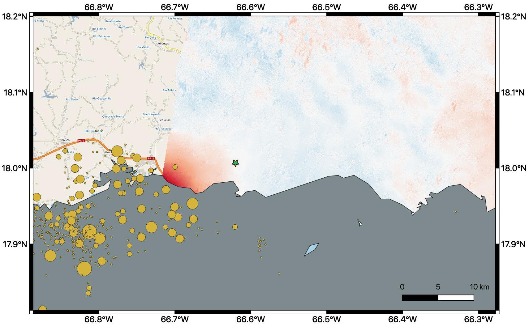
By comparing interferometric synthetic aperture radar (InSAR) data acquired on Jan. 9, 2020, with data acquired on Dec. 28, 2019, from the Copernicus Sentinel-1A satellite, NASA scientists were able to map where, how much and in what direction the ground shifted following a 6.4-magnitude earthquake off the coast of Puerto Rico.

Managed by the European Space Agency (ESA), the Copernicus Sentinel-1A satellite was able to see the eastern two-thirds of the island during the Jan. 9 flyover. On the map, red indicates areas where the ground was changed, or displaced, with darker shades corresponding to more significant displacement. The scientists found that the greatest displacement from the flyover area occurred west of the city of Ponce (identified by the green star), not far from the quake's offshore epicenter. They recorded up to 5.5 inches (14 centimeters) of ground change there. The ground appeared to shift downward and slightly to the west.

The epicenter of the quake and the cluster of quakes and aftershocks in the region identified by the United States Geological Survey (shown as orange circles) fall just west of the satellite's Jan. 9 track. Because of this, scientists also plan to analyze data from Sentinel-1A's forthcoming Jan. 14 flyover, which will include western Puerto Rico.

The NASA Earth Applied Sciences Disasters Program has activated Tier 1 response in support of this disaster, and is in contact with the Federal Emergency Management Agency, the United States Geological Survey and Health and Human Services to provide NASA Earth-observing data in support of response and recovery efforts.

For more information about ARIA, visit http://aria.jpl.nasa.gov.

Download JPG
Download TIFF
Target
  • Earth
Spacecraft
  • Copernicus Sentinel-1A
Credit
NASA/JPL-Caltech, ESA, USGS

Keep Exploring

About JPL
Who We Are
Directors
Careers
Internships
The JPL Story
JPL Achievements
Documentary Series
JPL Annual Report
Executive Council
Missions
Current
Past
Future
All
News
All
Earth
Solar System
Stars and Galaxies
Eyes on the News
Subscribe to JPL News
Galleries
Images
Videos
Audio
Podcasts
Apps
Visions of the Future
Slice of History
Robotics at JPL
Events
Lecture Series
Speakers Bureau
Calendar
Visit
Public Tours
Virtual Tour
Directions and Maps
Topics
JPL Life
Solar System
Mars
Earth
Climate Change
Exoplanets
Stars and Galaxies
Robotics
More
Asteroid Watch
NASA's Eyes Visualizations
Universe - Internal Newsletter
Social Media
Accessibility at NASA
Contact Us
Get the Latest from JPL
Follow Us

JPL is a federally funded research and development center managed for NASA by Caltech.

More from JPL
Careers
Education
Science & Technology
Acquisition
JPL Store
Careers
Education
Science & Technology
Acquisition
JPL Store
Related NASA Sites
Basics of Spaceflight
NASA Kids Science - Earth
Earth / Global Climate Change
Exoplanet Exploration
Mars Exploration
Solar System Exploration
Space Place
NASA's Eyes Visualization Project
Voyager Interstellar Mission
NASA
Caltech
Privacy
Image Policy
FAQ
Feedback
Version: v3.1.0 - 409b2d2
Site Managers:Emilee Richardson, Alicia Cermak
Site Editors:Naomi Hartono, Steve Carney
CL#:21-0018