JPL
Careers
Education
Science & Technology
JPL Logo
JPL Logo
Image

NASA's CloudSat Eyes Powerful Typhoon Utor

Jet Propulsion Laboratory https://www.jpl.nasa.gov/ Aug. 22, 2013
NASA's CloudSat satellite flew over Typhoon Utor in the West Pacific on Aug. 11, 2013 at 0518 UTC, passing within about 6.2 miles (10 kilometers) from the center of the storm, and revealing the structure of the storm's eye and eyewall.

click here for larger version for PIA17413click here for larger version for PIA17413click here for larger version for PIA17413
Figure 1Figure 2Figure 3
Click on an individual image for full resolution image

NASA's CloudSat satellite flew over Typhoon Utor in the West Pacific on Aug. 11, 2013 at 0518 UTC, passing within about 6.2 miles (10 kilometers) from the center of the storm, and revealing the structure of the storm's eye and eyewall. At the time, the storm contained estimated maximum strength winds of 132 miles per hour (115 knots) and had a minimum pressure of 937 millibars. Utor's strength was equivalent to a Category 4 strength hurricane.

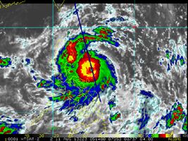
The CloudSat overpass reveals many unique features of a well-defined and intense typhoon (tropical cyclone) -- outward sloping eye and eyewall, rainband areas, moats and areas of high reflectivity (greater than 30dBZ). Heavy precipitation is distinguished by the attenuation of the radar (lack of signal) in the lowest 3.1 miles (5 kilometers) (up to almost 6.2 miles, or 10 kilometers, in the eyewall area) of the CloudSat swath. The CloudSat overpass reveals large amounts of liquid and ice water spread throughout the storm and also distinguishes rainband areas separated by moats (cloud-free areas) beneath the cirrus cloud-covered top of the storm. This is one a handful of cases where CloudSat has directly intersected the eye of a storm of this intensity and size.

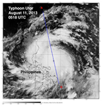
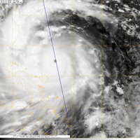
The Moderate Resolution Imaging Spectroradiometer (MODIS) on NASA's Aqua satellite captured the infrared image taken a few minutes before the CloudSat overpass (the blue line A-B on Figures 1, 2 and 3).

CloudSat is a satellite mission designed to measure the vertical structure of clouds from space. The radar data produces detailed images of cloud structures which will contribute to a better understanding of clouds and climate. Quicklook Images can viewed at the CloudSat Data Processing Center.

Download JPG
Download TIFF
Mission
Target
  • Earth
Spacecraft
  • Aqua
Instrument
  • Cloud Profiling Radar (CPR)
  • Moderate Resolution Imaging Spectroradiometer (MODIS)
Credit
NASA/JPL-Caltech/The Cooperative Institute for Research in the Atmosphere (CIRA), Colorado State University

Keep Exploring

NASA's CloudSat Images Dorian in 3D

NASA's CloudSat Passes Over Hurricane Michael

Taking a 3-D Slice of Hurricane Maria's Cloud Structure

Powerful Hurricane Irma Seen in 3D by NASA's CloudSat

NASA's CloudSat Sees Tropical Storm Harvey in 3D

CloudSat Takes a 3D Slice of Hurricane Matthew

NASA's CloudSat Peers Into the Eye of Powerful Typhoon Dolphin

CloudSat's View of Hurricane Sandy

NASA's CloudSat Views Hurricane Sandy

NASA's CloudSat Spots Beginning of Pakistan Floods

About JPL
Who We Are
Directors
Careers
Internships
The JPL Story
JPL Achievements
Documentary Series
JPL Annual Report
Executive Council
Missions
Current
Past
Future
All
News
All
Earth
Solar System
Stars and Galaxies
Eyes on the News
Subscribe to JPL News
Galleries
Images
Videos
Audio
Podcasts
Apps
Visions of the Future
Slice of History
Robotics at JPL
Events
Lecture Series
Speakers Bureau
Calendar
Visit
Public Tours
Virtual Tour
Directions and Maps
Topics
JPL Life
Solar System
Mars
Earth
Climate Change
Exoplanets
Stars and Galaxies
Robotics
More
Asteroid Watch
NASA's Eyes Visualizations
Universe - Internal Newsletter
Social Media
Accessibility at NASA
Contact Us
Get the Latest from JPL
Follow Us

JPL is a federally funded research and development center managed for NASA by Caltech.

More from JPL
Careers
Education
Science & Technology
Acquisition
JPL Store
Careers
Education
Science & Technology
Acquisition
JPL Store
Related NASA Sites
Basics of Spaceflight
NASA Kids Science - Earth
Earth / Global Climate Change
Exoplanet Exploration
Mars Exploration
Solar System Exploration
Space Place
NASA's Eyes Visualization Project
Voyager Interstellar Mission
NASA
Caltech
Privacy
Image Policy
FAQ
Feedback
Version: v3.1.0 - 409b2d2
Site Managers:Emilee Richardson, Alicia Cermak
Site Editors:Naomi Hartono, Steve Carney
CL#:21-0018