Focusing the 100-millimeter Mastcam
 |  |
| Figure 1 | Figure 2 |
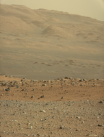
The 100-millimeter Mastcam has three times better resolution than Curiosity's 34-millimeter Mastcam, though it has a narrower field of view. For comparison, see PIA16103.
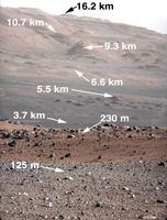
The gravelly area around Curiosity's landing site is visible in the foreground. Farther away, about a third of the way up from the bottom of the image, the terrain falls off into a depression (a swale). Beyond the swale, in the middle of the image, is the boulder-strewn, red-brown rim of a moderately-sized impact crater. Farther off in the distance, there are dark dunes and then the layered rock at the base of Mount Sharp. Some haze obscures the view, but the top ridge, depicted in this image, is 10 miles (16.2 kilometers) away.
Scientists enhanced the color in one version to show the Martian scene under the lighting conditions we have on Earth, which helps in analyzing the terrain. A raw version is also available.
An annotated version of the image indicates the distances to different features. They were calculated using a computer program that analyzes data from the High Resolution Imaging Science Experiment (HiRISE) camera aboard NASA's Mars Reconnaissance Orbiter.
To see a close-up of the layered buttes of Mount Sharp, see PIA16105.
JPL manages the Mars Science Laboratory/Curiosity for NASA's Science Mission Directorate in Washington. The rover was designed, developed and assembled at JPL, a division of the California Institute of Technology in Pasadena.
For more about NASA's Curiosity mission, visit: http://www.jpl.nasa.gov/msl, http://www.nasa.gov/mars, and http://marsprogram.jpl.nasa.gov/msl.
