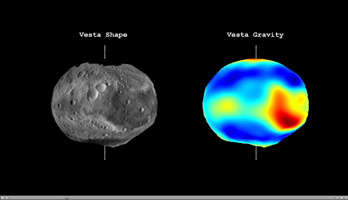
Vesta Shape and Gravity

Click on the image for the video
This video from NASA's Dawn mission shows that the gravity field of Vesta closely matches the surface topography of the giant asteroid Vesta. The video shows shaded topography from Dawn's framing camera on the left, with troughs and craters visible, and color-contoured data from Dawn's gravity experiment on the right. Red shows the areas with a higher than average gravity field and blue-purple shows the areas where the field is weaker on average. The highest topography, on the rim of the Rheasilvia basin deep in the southern hemisphere, shows a particularly strong gravity field. The dashed line indicates the north-south axis.
The topography model is derived from framing camera images from Dawn's high-altitude mapping orbit (420 miles or 680 kilometers above the surface), and the gravity data come from the low-altitude mapping orbit (130 miles or 210 kilometers above the surface).
Vesta takes approximately 5.34 hours to make a rotation.
The Dawn mission to Vesta and Ceres is managed by NASA's Jet Propulsion Laboratory, a division of the California Institute of Technology in Pasadena, for NASA's Science Mission Directorate, Washington. UCLA is responsible for overall Dawn mission science. The Dawn framing cameras were developed and built under the leadership of the Max Planck Institute for Solar System Research, Katlenburg-Lindau, Germany, with significant contributions by DLR German Aerospace Center, Institute of Planetary Research, Berlin, and in coordination with the Institute of Computer and Communication Network Engineering, Braunschweig. The framing camera project is funded by the Max Planck Society, DLR and NASA/JPL.
More information about the Dawn mission is online at http://www.nasa.gov/dawn and http://dawn.jpl.nasa.gov.
