JPL
Careers
Education
Science & Technology
JPL Logo
JPL Logo
Image

Measuring Water Storage in the Amazon
July 7, 2010
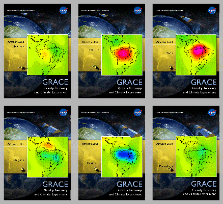
This image is from data taken by NASA's Gravity Recovery and Climate Experiment showing the Amazon basin in South America. The amount of water stored in the Amazon basin varies from month to month.
Animations are available at the Photojournal.

click here for animated version for PIA13243click here for animated version for PIA13243
Click on an individual image for larger animations

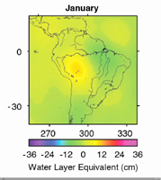
This image shows the Amazon basin in South America. The amount of water stored in the Amazon basin varies from month to month, and can be monitored from space by looking at how it alters Earth's gravity field. This series of images was produced using data from Gravity Recovery and Climate Experiment (GRACE) in 2008 and shows month-to-month water mass changes (relative to a three-year average) over the Amazon and neighboring regions. Oranges, reds and pinks show where mass is lower than average; greens, blues and purples show where mass is higher than average. The Amazon has distinct rainy and dry seasons, and the seasons show up clearly through the monthly maps. Notice also that the smaller Orinoco basin to the north of the Amazon has a distinctly different seasonal pattern.

NASA launched GRACE in 2002 to obtain high-resolution, global measurements of Earth's gravity field from space. After seven years, GRACE continues to reveal increasingly subtle changes in Earth's gravity field. These gravity variations reflect changes in the distribution of Earth's mass, including changes in water storage in river basins on land, changes in ice mass in Greenland and Antarctica, ocean mass changes, and even changes caused by large earthquakes. GRACE data are substantially improving our knowledge of important aspects of global change, including the climate consequences of a warming world.

As GRACE's twin satellites pass over features on Earth, the distance between the satellites changes ever so slightly in response to the mass of these features. Extremely sensitive instruments on GRACE can measure changes in the distance between the twin satellites to an accuracy of 1 micrometer (one-millionth of a meter), which is 20 to 100 times smaller than the width of a human hair. As GRACE orbits, it provides data for scientists to construct a new map of Earth's gravity field every month.

Data from GRACE help scientists monitor changes in water storage over large areas, as illustrated in the animation. Gravity changes correspond to redistribution in Earth's mass, and scientists can isolate the part that is caused by the movement of water. Hydrologists go a step further and combine information from GRACE with soil moisture and other data to isolate changes in groundwater storage, which is otherwise very difficult to measure, but whose monitoring has global societal impact. This also allows them, for example, to monitor monthly water storage changes in aquifers where appropriate.

GRACE is a collaborative endeavor involving the Center for Space Research at the University of Texas, Austin; NASA's Jet Propulsion Laboratory, Pasadena, Calif.; the German Space Agency and Germany's National Research Center for Geosciences, Potsdam.

Download JPG
Download TIFF
Mission
Target
  • Earth
Spacecraft
  • GRACE Satellite
Instrument
  • K-Band Ranging System
Credit
NASA/JPL/University of Texas Center for Space Research

Keep Exploring

Monthly GRACE Gravity Anomaly Maps

Cumulative Total South America Freshwater Losses as Seen by NASA's GRACE, 2002-15

Cumulative Total U.S. Freshwater Losses as Seen by NASA's GRACE, 2002-15

Cumulative Total Middle East/North Africa Freshwater Losses as Seen by NASA's GRACE, 2002-15

Cumulative Total India Freshwater Losses as Seen by NASA's GRACE, 2002-15

Study: Third of Big Groundwater Basins in Distress

NASA's GRACE Sees a Drying California

GRACE Measures Groundwater Changes Across the U.S.

Ice Mass Loss on Greenland, 2003-2011

Greenland Gains Some, Loses More

Related Topics

News .

NASA Helps Study One of the World’s Most Diverse Ecosystems

News .

Google’s ‘A Passage of Water’ Brings NASA’s Water Data to Life

News .

NASA Mission Excels at Spotting Greenhouse Gas Emission Sources

News .

Trailblazing New Earth Satellite Put to Test in Preparation for Launch

News .

NASA Analysis Finds Strong El Niño Could Bring Extra Floods This Winter

News .

NASA Flights Link Methane Plumes to Tundra Fires in Western Alaska

Video .

Methane Hot Spots

News .

See SWOT Mission’s Unprecedented View of Global Sea Levels

News .

NASA-ISRO Radar Mission to Provide Dynamic View of Forests, Wetlands

News .

International Ocean Satellite Monitors How El Niño Is Shaping Up

About JPL
Who We Are
Executive Council
Directors
Careers
Internships
The JPL Story
JPL Achievements
Documentary Series
Annual Reports
JPL Plan: 2023-2026
Missions
Current
Past
Future
All
News
All
Earth
Solar System
Stars and Galaxies
Subscribe to JPL News
Galleries
Images
Videos
Audio
Podcasts
Apps
Visions of the Future
Slice of History
Robotics at JPL
Events
Lecture Series
Team Competitions
Speakers Bureau
Calendar
Visit
Public Tours
Virtual Tour
Directions and Maps
Topics
JPL Life
Solar System
Mars
Earth
Climate Change
Exoplanets
Stars and Galaxies
Robotics
More
Asteroid Watch
NASA's Eyes Visualizations
Universe - Internal Newsletter
Social Media
Get the Latest from JPL
Follow Us

JPL is a federally funded research and development center managed for NASA by Caltech.

More from JPL
Careers Education Science & Technology Acquisition JPL Store
Careers
Education
Science & Technology
Acquisition
JPL Store
Related NASA Sites
Basics of Spaceflight
Climate Kids
Earth / Global Climate Change
Exoplanet Exploration
Mars Exploration
Solar System Exploration
Space Place
NASA's Eyes Visualization Project
Voyager Interstellar Mission
NASA
Caltech
Privacy
Image Policy
FAQ
Feedback
Site Managers: Veronica McGregor, Randal Jackson
Site Editors: Tony Greicius, Naomi Hartono
CL#: 21-0018