New Impact Craters on Mars

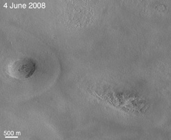 |  |
| Figure 1 Annotated Image No Annotation | Figure 2 Annotated Image No Annotation |
The team operating the Context Camera (CTX) aboard NASA's Mars Reconnaissance Orbiter frequently discovers new dark spots on Mars that, upon closer examination, turn out to be brand new impact craters. Sometimes only a single crater is present, but often there is a cluster of several craters. Depending on the patterns and size, crater clusters are interpreted as indicating that the incoming meteorite broke apart before it hit the surface. In some cases, clusters could be formed by ejecta from other, larger impact craters.
Shown above are subframes of two Context Camera images of terrain in western Arcadia Planitia (near 46.7 degrees north latitude, 183.2 degrees west longitude). Each covers an area about 6.5 kilometers (4 miles) across. The first (figure 1) was taken on June 4, 2008, the second (figure 2) on Aug. 10, 2008. Between the time the two images were acquired, a cluster of dark spots -- and dark rays radial to some of the dark spots -- formed. The camera team immediately considered this to be a candidate new meteor impact site, but Context Camera images have a resolution of 6 meters (19.7 feet) per pixel. This means that features, including impact craters, smaller than about 20 to 25 meters (65 to 82 feet) across cannot usually be resolved. Thus, most of the dark spots (like these) that the Context Camera team finds and suspects to be new impact craters have to be imaged at higher resolution to find out whether small impact craters are actually present.
To confirm that the features were craters, the Context Camera team created an opportunity for the team operating the High Resolution Imaging Science Experiment (HiRISE) camera, which is also on the Mars Reconnaissance Orbiter, to take a picture of the site. This camera makes images of Mars' surface with a resolution of about 30 centimeters (1 foot) per pixel. Such images can be used to identify objects as small as about a meter (3 feet) across. The Context Camera team targeted its camera to take a new picture centered on the candidate impact site and made a request to the High Resolution Imaging Science Experiment team to take a picture at the same time.
Meanwhile, the Context Camera team also did some homework: Before asking for the High Resolution Imaging Science Experiment to look at candidate new impact sites, such as the dark spots shown here, they make the best determination possible as to when the features formed. If the features result from a meteor impact, then the team can state approximately when the impact occurred. In the case shown here, the impact occurred sometime between June 4 and Aug. 10, 2008. At the time it was found, this candidate impact site was so new that the Context Camera team very quickly suggested that the High Resolution Imaging Science Experiment take a look so that a good example of a very new impact site could be examined.
That interest -- and the Context Camera team's quick work -- paid off. The High Resolution Imaging Science Experiment team obtained a picture of the site on Sept. 12, 2008, just a month after the Aug. 10 Context Camera image was received on Earth and evaluated. The Sept. 12 image, HiRISE PSP_009978_2265, shows a nice cluster of new impact craters. Some of the craters exposed a light-toned material that appeared somewhat bluish in the High Resolution Imaging Science Experiment's color data. Immediately suspecting the material to be an exposure of subsurface ice, the High Resolution Imaging Science Experiment team began a campaign to monitor this site to see if the bright material changed. It did, suggesting that perhaps the material was going away, just as ice might do at that time of year (summer in Mars' northern hemisphere). The two camera teams worked during the next several months to identify more such craters and, in the end, found a total of five brand new impact crater sites at northern middle latitudes that seemed to have exposed buried water ice. At the same time, the camera teams encouraged the team operating the Compact Reconnaissance Imaging Spectrometer for Mars (CRISM), a third instrument on the Mars Reconnaissance Orbiter, to obtain multispectral infrared observations. Most of the craters and bright patches were too small for the spectrometer to resolve, but one of them was large enough that the spectrometer team did, in fact, confirm that the light-toned material was water ice.
Details and scientific interpretation of these new impact craters and their use to examine subsurface ice at northern mid-latitudes on Mars are captured in a paper published this week in Science by Shane Byrne and 17 colleagues on teams operating the Contect Camera, High Resolution Imaging Science Experiment, and Compact Reconnaissance Imaging Spectrometer for Mars. All of that effort began with a single pair of Context Camera images, the two shown here. If the Context Camera team had not found these first two images and had not immediately attempted to re-image the suspected crater cluster and provide an opportunity for High Resolution Imaging Science Experiment to "ride along," then the most important aspect of the observations reported in Science -- the presence of excavated ground ice -- would have been lost because the ice began to disappear or darken immediately after the impacts occurred.
The two pictures are map-projected subframes of Context Camera images P20_008699_2247_XN_44N182W and P22_009556_2263_XI_46N183W. The scale bar is 500 meters (1,640 feet) long. North is up and sunlight illuminates the scenes from the lower left. Both images are archived with the NASA Planetary Data System Imaging Subnode.