
Global Views of Atmospheric Water Vapor:<br />First Data from OSTM/Jason-2's Advanced Microwave Radiometer

 |  |
| Figure 1 Click on image for higher resolution | Figure 2 Click on image for higher resolution |
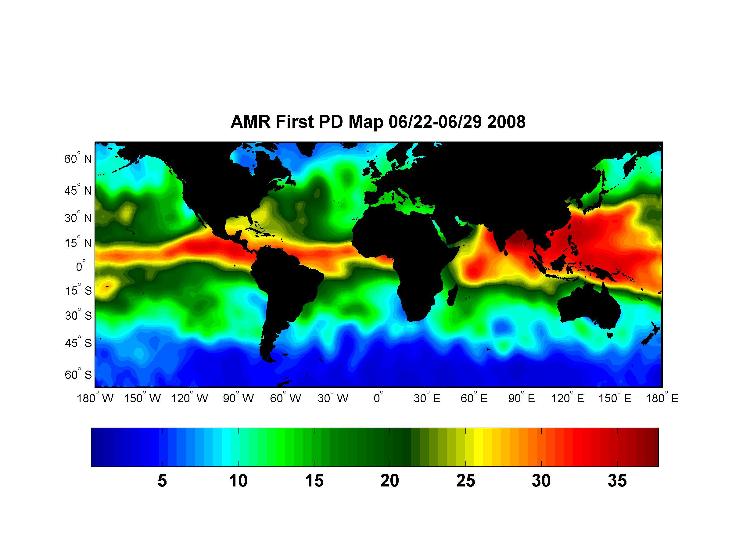
The top image (figure 1) is the first global wet path delay map created with data from the Advanced Microwave Radiometer (AMR) onboard the Ocean Surface Topography Mission/Jason-2 satellite. The spacecraft, launched on June 20, 2008, uses a radar altimeter to measure ocean height. The science instruments on the spacecraft were turned on for the first time after launch on June 22 and began returning data almost immediately. This map shows the amount of water vapor in the atmosphere beneath the satellite during the period June 22, 2008, to June 29, 2008.
Water vapor will delay the time it takes for the radar pulse from the spacecraft's altimeter to travel to the ocean surface and back. By knowing exactly how much water vapor is in the signal's path together with the time it takes for the signal to bounce back, mission scientists can calculate the exact distance between the satellite and the ocean surface. This information along with the precise location of the spacecraft allows them to determine the height of the sea surface to just a few centimeters from measurements made 800 miles above Earth.
Like the altimeter, the radiometer looks straight down at the ocean surface. It senses three microwave wavelengths: the signature thermal signals emitted by water vapor, clouds and the ocean surface roughed up by wind. The measurements at the three wavelengths are used together to derive the total amount of water vapor present in the atmosphere in the altimeter's path. In this image, blues represent dry areas where there is little water to delay the radar signal and reds represent moist regions where the signal will be slowed. The color index at the bottom shows the path delay value in the map in units of centimeters.
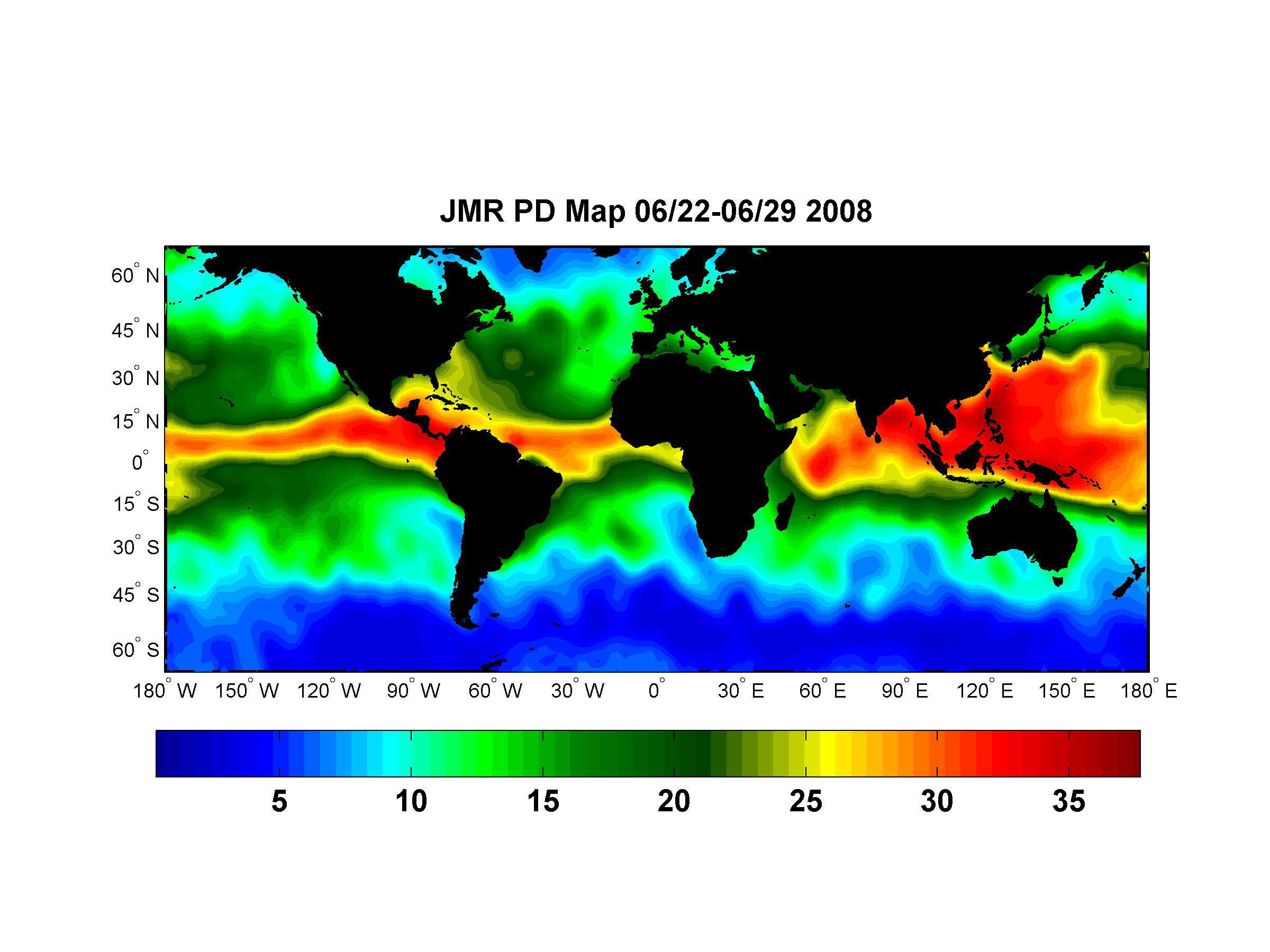
The lower image (figure 2) is a wet path delay map created with data from the Jason Microwave Radiometer (JMR) on the Jason-1 satellite collected during the same time period. Jason-1 has been using an altimeter to measure the height of the ocean since 2001. OSTM/Jason-2 and Jason-1 are now flying in the same orbit, only 55 seconds apart, while mission personnel ensure that the new satellite is working well and that its measurements are accurate. The similarity between the two path delay maps shows that the two radiometers are in close agreement.
When its calibration and validation period is complete, OSTM/Jason-2 will remain in the orbit now occupied by Jason-1 and will continue the long-term record of ocean surface topography begun by Topex/Poseidon in 1992 and carried on by Jason-1. Jason-1 will be moved to a new orbit beside OSTM/Jason-2 to provide additional measurements of ocean surface topography for as long as the older spacecraft remains healthy.
Both the radiometers onboard OSTM/Jason-2 and Jason-1 were built at NASA's Jet Propulsion Laboratory, Pasadena, Calif.
OSTM/Jason-2 is a collaboration between NASA; the National Oceanic and Atmospheric Administration (NOAA); CNES; and the European Organisation for the Exploitation of Meteorological Satellites (EUMETSAT). After completing the on-orbit commissioning of the spacecraft, CNES will hand over its operation and control to NOAA. NOAA and EUMETSAT will generate the near-real-time products and distribute them to users. JPL manages the mission for NASA's Science Mission Directorate in Washington.
More information about the mission is available at http://sealevel.jpl.nasa.gov/.