JPL
Careers
Education
Science & Technology
JPL Logo
JPL Logo
Image

Complex exposures of North Polar layered material

Jet Propulsion Laboratory https://www.jpl.nasa.gov/ Jan. 13, 2001
NASA's Mars Global Surveyor shows many layers exposed and eroded into the form of ridges and troughs on shallow slopes within the martian north polar cap.

A. PIA02897


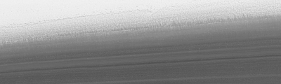
86.5°N, 324.0°W --- 16 December 2000 --- illuminated from lower left 10 km (6.2 mi) wide by 3 km (1.9 mi) high
B. PIA02898


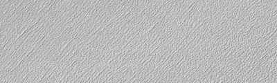
85.7°N, 307.9°W --- 2 December 2000 --- illuminated from upper left 2 km (1.2 mi) wide by 0.9 km (0.6 mi) high
C. PIA02899


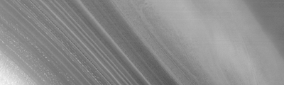
87.0°N, 263.8°W --- 12 December 2000 --- illuminated from upper left 10 km (6.2 mi) wide by 3 km (1.9 mi) high

On Mars, Northern Hemisphere Summer (and Southern Hemisphere Winter) began on December 16, 2000. In this December holiday season, many children across the U.S. and elsewhere are perhaps anticipating an annual visit from a generous and jolly red-suited soul from the Earth's North Pole. As the December holidays were approaching, the Mars Global Surveyor (MGS) Mars Orbiter Camera (MOC) was busy acquiring new views of the region around the martian north pole. The three best views obtained this month are shown here. The top (A) and bottom (C) views show many layers exposed and eroded into the form of ridges and troughs on shallow slopes within the martian north polar cap. The middle (B) view is a picture of the rugged, eroded polar ice cap surface itself. The layers are believed to have formed over tens to hundreds of thousands of years by deposition of dust and ice each cold martian winter. These surfaces today all appear to have been eroded. The brightest material in each image is frost--temperatures at this time of year indicate that the frost is composed of frozen water. In winter, temperatures can be cold enough to freeze carbon dioxide, as well.

Download JPG
Download TIFF
Mission
Target
  • Mars
Spacecraft
  • Mars Global Surveyor Orbiter
Instrument
  • Mars Orbiter Camera (MOC)
Credit
NASA/JPL/MSSS

Keep Exploring

A Water Ice Map for Mars

Jezero Crater's Ancient Lakeshore

Growth and Retreat of the CO2 Ice at the Martian Poles

Hydrologic Modeling of Relatively Recent Martian Streams and Lake

Landscape of Former Lakes and Streams on Northern Mars

Using Gravity and Topography to Map Mars' Crustal Thickness

Newly Detailed Map of Mars' Crustal Thickness

Maps of Recurrent Slope Linea Markings on Mars

Locations of Ice-Exposing Fresh Craters on Mars

NASA's Mars Landing Sites, including InSight

About JPL
Who We Are
Directors
Careers
Internships
The JPL Story
JPL Achievements
Documentary Series
JPL Annual Report
Executive Council
Missions
Current
Past
Future
All
News
All
Earth
Solar System
Stars and Galaxies
Eyes on the News
Subscribe to JPL News
Galleries
Images
Videos
Audio
Podcasts
Apps
Visions of the Future
Slice of History
Robotics at JPL
Events
Lecture Series
Speakers Bureau
Calendar
Visit
Public Tours
Virtual Tour
Directions and Maps
Topics
JPL Life
Solar System
Mars
Earth
Climate Change
Exoplanets
Stars and Galaxies
Robotics
More
Asteroid Watch
NASA's Eyes Visualizations
Universe - Internal Newsletter
Social Media
Accessibility at NASA
Contact Us
Get the Latest from JPL
Follow Us

JPL is a federally funded research and development center managed for NASA by Caltech.

More from JPL
Careers
Education
Science & Technology
Acquisition
JPL Store
Careers
Education
Science & Technology
Acquisition
JPL Store
Related NASA Sites
Basics of Spaceflight
NASA Kids Science - Earth
Earth / Global Climate Change
Exoplanet Exploration
Mars Exploration
Solar System Exploration
Space Place
NASA's Eyes Visualization Project
Voyager Interstellar Mission
NASA
Caltech
Privacy
Image Policy
FAQ
Feedback
Version: v3.1.0 - 409b2d2
Site Managers:Emilee Richardson, Alicia Cermak
Site Editors:Naomi Hartono, Steve Carney
CL#:21-0018