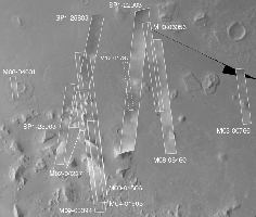
Cydonia: Two Years Later

Click on Image for larger view
The above figure shows the location of all high resolution (narrow angle) MOC images of the Cydonia region that have been obtained to date, including the first three taken in 1998 (PIA01240, PIA01241, AND PIA01440). These images are superimposed upon a mosaic of Viking images taken during the 1970's. Images acquired during the Science Phasing Orbit period of 1998 slant from bottom left to top right; Mapping Phase images (from 1999 and 2000) slant from lower right to upper left. Owing to the nature of the orbit, and in particular to the limitations on controlling the location of the orbit, the longitudinal distribution of images (left/right in the images above) is distinctly non-uniform. An attempt to take a picture of a portion of the "Face" itself in mid-February 2000 was foiled when the MGS spacecraft experienced a sequencing error and most of that day's data were not returned to Earth. Only the first 97 lines were received; the image's planned footprint is shown as a dashed box. This image is one in a series of eight.
