The Dark Surfaces of Mars: Mantles and Sand Sheets
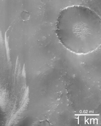
 (A) Sinus Sabaeus, dark mantle and bright drifts. |

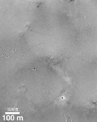
(B) Sinus Sabaeus, dark mantle with cracks.
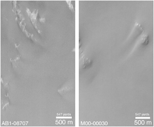
 (C) Ganges Chasma Sand Sheet. |

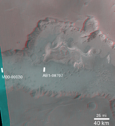
(D) Ganges Chasma 3-D Context.
Since the Mariner missions to Mars (1965-1972), purely geological explanations have been proposed to explain the dark regions and the changes we see in them. In particular, dust storms have been observed on Mars. Thus wind and dust storms are the suspected culprits that created the 19th Century illusion that something was growing and changing with each martian season. Just as there are "hurricane seasons" and "monsoon seasons" on Earth, there may be "dust storm seasons" on Mars.
The dark regions of Mars are now being seen in greater detail than ever before by the Mars Global Surveyor (MGS) Mars Orbiter Camera (MOC). As expected, none of these areas are covered by vegetation! But what has been a surprise is the great variety of dark surfaces seen. Before MGS, most had been thinking that these areas are sandy because all of the large martian sand dunes are dark, too. But in many cases, dark dunes and sand are not found in the MOC images -- such areas instead are thickly blanketed by a cracked, crusty covering of what may be fine silt instead of sand. Other areas -- in particular the floor of Ganges Chasma in the Valles Marineris region -- show thick accumulations of windblown sand.
The first two pictures presented here (A and B, above) show dark, blanketed or mantled surfaces in the Sinus Sabaeus region (310°-350° W longitude and 5°-12°S latitude) of Mars. This dark material in some places has bright dunes on top of it (top, left picture), and in other places appears to have narrow cracks running through it (top, right picture). If the dark material consisted of sand, it would show drifts and tails formed around and behind obstacles as are seen in the thick sand sheets of Ganges Chasma (C and D, above). Because wind transports sand close to the ground, it interacts with obstacles such as the bright mounds in Figure C (above) to make drifts and tails.
The top left picture is MOC image AB1-11105 located in Sinus Sabaeus near 7.0°S, 343.4°W. The top right picture is also in Sinus Sabaeus and is MOC image M00-01078 near 10.0°S, 329.1°W. The bottom left pair of images show a thick sheet of dark sand in Ganges Chasma. The bottom right picture is a stereo anaglyph (use 3-d red/blue glasses) MOC wide angle view showing the locations of the two Ganges Chasma images. Ganges Chasma is around 7°S, 50°W. All pictures are illuminated from the left. The AB1 images were taken in January 1998, the M00 images are from April 1999.
