JPL
Careers
Education
Science & Technology
JPL Logo
JPL Logo
Image

Ancient Paleo-Dunes Battered by Impact Craters

Jet Propulsion Laboratory https://www.jpl.nasa.gov/ April 29, 2000
NASA's Mars Global Surveyor shows a field of parallel ridges north of a dune field in a wind-eroded material named the Apollinaris Sulci on Mars.

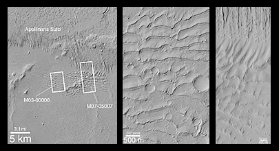
A pair of Mars Global Surveyor (MGS) Mars Orbiter Camera (MOC) images (above, center and right) shows close-up views of a sand dune field that was first detected by the Viking orbiters in the late 1970s (above, left). What is surprising about the MOC images is that they reveal a dune field unlike any other thus far seen on Mars--this one has impact craters on its surface, and LOTS of them!

The field of parallel ridges north of the dune field (above the white boxes in picture at the left) is a wind-eroded material named the Apollinaris Sulci. It is possible that the dune field shown here was once covered by this wind-eroded material and was later exhumed. Regardless, the dunes were somehow hardened and have been exposed as hard rock on the martian surface long enough for many impact craters smaller than a few hundred meters (few hundred yards) across to form. These dunes are therefore quite ancient -- one might say that this is a "fossil" dune field. A similar effect at a much smaller scale can be seen by examining some sandstones and siltstones on Earth -- if conditions were right, ripples formed in either water or wind are preserved in such rocks.

The first MOC view, labeled M03-00006, was taken on July 1, 1999. The second view, M07-05007, was acquired September 26, 1999. Both MOC images and the Viking picture are illuminated from the left. The dune field occurs east of the Apollinaris Patera volcano and northeast of Gusev Crater at 12.5°S, 181°W.

The release for image C in the caption can be found here.

Download JPG
Download TIFF
Mission
Target
  • Mars
Spacecraft
  • Mars Global Surveyor Orbiter
Instrument
  • Mars Orbiter Camera (MOC)
Credit
NASA/JPL/MSSS

Keep Exploring

A Water Ice Map for Mars

Jezero Crater's Ancient Lakeshore

Growth and Retreat of the CO2 Ice at the Martian Poles

Landscape of Former Lakes and Streams on Northern Mars

Hydrologic Modeling of Relatively Recent Martian Streams and Lake

Using Gravity and Topography to Map Mars' Crustal Thickness

Newly Detailed Map of Mars' Crustal Thickness

Maps of Recurrent Slope Linea Markings on Mars

Locations of Ice-Exposing Fresh Craters on Mars

NASA's Mars Landing Sites, including InSight

About JPL
Who We Are
Directors
Careers
Internships
The JPL Story
JPL Achievements
Documentary Series
JPL Annual Report
Executive Council
Missions
Current
Past
Future
All
News
All
Earth
Solar System
Stars and Galaxies
Eyes on the News
Subscribe to JPL News
Galleries
Images
Videos
Audio
Podcasts
Apps
Visions of the Future
Slice of History
Robotics at JPL
Events
Lecture Series
Speakers Bureau
Calendar
Visit
Public Tours
Virtual Tour
Directions and Maps
Topics
JPL Life
Solar System
Mars
Earth
Climate Change
Exoplanets
Stars and Galaxies
Robotics
More
Asteroid Watch
NASA's Eyes Visualizations
Universe - Internal Newsletter
Social Media
Accessibility at NASA
Contact Us
Get the Latest from JPL
Follow Us

JPL is a federally funded research and development center managed for NASA by Caltech.

More from JPL
Careers
Education
Science & Technology
Acquisition
JPL Store
Careers
Education
Science & Technology
Acquisition
JPL Store
Related NASA Sites
Basics of Spaceflight
NASA Kids Science - Earth
Earth / Global Climate Change
Exoplanet Exploration
Mars Exploration
Solar System Exploration
Space Place
NASA's Eyes Visualization Project
Voyager Interstellar Mission
NASA
Caltech
Privacy
Image Policy
FAQ
Feedback
Version: v3.1.0 - 409b2d2
Site Managers:Emilee Richardson, Alicia Cermak
Site Editors:Naomi Hartono, Steve Carney
CL#:21-0018