With 15 years of monitoring how water and ice are distributed on our planet, the GRACE mission proved its value for monitoring and studying the global water cycle so thoroughly that the recent Earth Science Decadal Survey report released by the National Academy of Sciences in December 2017 listed measurement of mass changes as one of five top priorities in Earth observations for the next decade. The same recognition of GRACE's value led to the recommendation in NASA’s 2010 Climate Architecture report to develop GRACE-FO as a directed NASA mission.
WHY WE NEED
MORE GRACE
WHAT DOES GRAVITY HAVE TO DO WITH WATER?
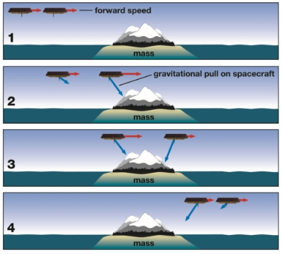
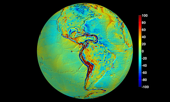
"Everything flows." These famous words by the ancient Greek philosopher Heraclitus express the truth that our complex world is ever-changing and evolving. Even Earth’s gravity is continually changing. The pull of gravity varies naturally from place to place on Earth, depending on the mass at the surface; greater mass exerts a stronger gravitational pull. But this geographically varying gravity itself also changes constantly as mass moves in time. The land and ocean move and change relatively slowly, but water mass on the land -- or above or below it -- changes daily.
On Earth, the processes that cause water to move and change are fundamental to today's most pressing climate science challenges. But keeping track of Earth’s evolving water cycle is a formidable task. Water constantly changes its shape, form and state as it moves between oceans, atmosphere and land. It can be in plain sight in a lake or hidden in an aquifer underground. It can evaporate from Earth's surface in moments after a rain shower or be stored for hundreds or thousands of years as ice in glaciers and ice sheets.
But regardless of whether water is solid, liquid or vapor, visible or invisible, it has one attribute that does not change: its mass. And since mass has a gravitational pull associated with it, engineers and scientists have come up with a unique twin-satellite observing system that uses the changing forces of gravity to track and follow Earth’s water masses from the top of the Himalaya to the deepest ocean depths and deep underground. The record of changing gravity and changing mass, combined with sea surface height observations, is directly linked with the heat trapped on Earth by greenhouse gases and stored in the ocean.
The concept of using two satellites flying in formation to measure gravity and its changes can be traced back to the late 1960s. But it wasn’t until the 1990s that advances in technology, notably GPS, enabled the development of a viable flight mission. Researchers and engineers led by Byron Tapley of the University of Texas at Austin and Michael Watkins, now director of NASA's Jet Propulsion Laboratory in Pasadena, California, came together and realized the unique potential for new Earth observations and data that could be gleaned from measuring variations in gravity. They proposed the GRACE mission to NASA and won the competition under NASA’s Earth System Science Pathfinder program.
HOW GRACE FOLLOW-ON WORKS
Like its predecessor, the GRACE-FO mission consists of two identical satellites orbiting Earth about 137 miles (220 kilometers) apart, one behind the other, at an initial altitude of approximately 305 miles (490 kilometers). One of the unique aspects of GRACE and GRACE-FO is that the pair of satellites themselves are the “instrument.” Unlike other Earth-observing satellites, which are equipped with instruments pointing down at Earth’s surface to measure some property of the electromagnetic spectrum such as light or heat, the GRACE-FO satellites instead “look” at each other and measure the varying distance between themselves. Together, they represent a single measurement system.
As one satellite follows the other along the same orbit, both continually send microwave signals to each other and use the incoming signals to accurately measure the distance that separates them, tracking any changes. As the GRACE-FO satellites fly over a massive Earth feature -- such as a mountain range or underground aquifer -- the distance between the two satellites will change by a fraction of the thickness of a human hair. By accurately tracking how the satellites’ separation distance changes during each orbit and over time, it is possible to detect gravity changes that vary by region with high precision.
A GPS system keeps track of each spacecraft’s position relative to Earth's surface, and onboard accelerometers record forces on the spacecraft other than gravity, such as atmospheric drag and solar radiation. These data are then combined to produce monthly maps of the regional variations in global gravity and the corresponding surface mass variations.
THE WEIGHT OF WATER
GRACE's observations are so different from other types of hydrology data that researchers had to develop innovative techniques before they could use the new data set and combine it with other observations and models. Within a year or two of launch, however, the GRACE data record began yielding new insights into how the water cycle is changing, especially in places almost impossible to monitor from the surface. Sixteen years later, researchers continue to develop new techniques to process and analyze the data to obtain information that's not measured by other sensors. There's every reason to expect innovative uses to continue with GRACE-FO.
Here are a few areas where GRACE has revolutionized our understanding.
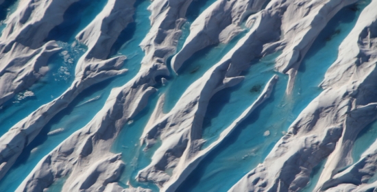
In the decades before GRACE, only limited observations of melting ice in Greenland and Antarctica from the ground or by remote sensing were available -- not enough even to be sure whether Antarctica's ice sheet was growing or shrinking overall. Within a few years of its launch, several university research groups were able to calculate that ice losses from both ice sheets were dramatically larger than some previous estimates had suggested. Since GRACE launched, its measurements have shown Greenland has been losing about 280 gigatons of ice per year on average, and Antarctica has lost almost 120 gigatons a year, with indications that both melt rates are increasing. One gigaton of water would fill about 400,000 Olympic-sized swimming pools.
Isabella Velicogna of JPL and the University of California, Irvine, and colleagues recently used GRACE data to estimate that ice loss has also accelerated over 2003-2013 by about 25 gigatons per year every year in Greenland and 11 gigatons per year every year in Antarctica. If the acceleration continues, the melting of the two ice sheets will be the dominant contributor to sea level rise in the 21st century.
Melt ponds on the Greenland ice sheet
Image credit: NASA / OIB / John Sonntag
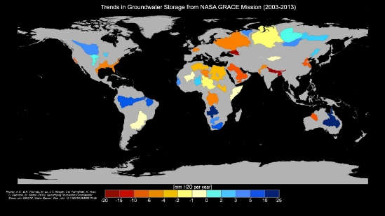
Water stored in aquifers below Earth's surface is very sparsely measured worldwide. GRACE has given us the first regional and global-scale measurements of this significant freshwater resource. The data measure changes in underground water mass, so it is not possible to know how much water remains underground. Over the last decade, however, hydrologists including Matt Rodell of NASA's Goddard Space Flight Center in Greenbelt, Maryland, and Jay Famiglietti of NASA's Jet Propulsion Laboratory in Pasadena, California, have found more and more locations where humans are pumping out groundwater faster than it is replenished. In 2015, their team published a comprehensive survey showing a third of Earth's largest groundwater basins are being rapidly depleted.
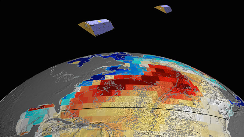
Groundwater storage map
Image credit: UC Irvine/NASA/JPL-Caltech
Dry soils can add to drought risk or increase the length of a drought. Rodell (NASA GSFC) and his team provide GRACE-derived data on deep soil moisture and groundwater to the National Drought Mitigation Center each week, using a hydrology model to calculate how the moisture is changing throughout the month between one map and the next. The data are used in preparing weekly maps of U.S. drought risk.
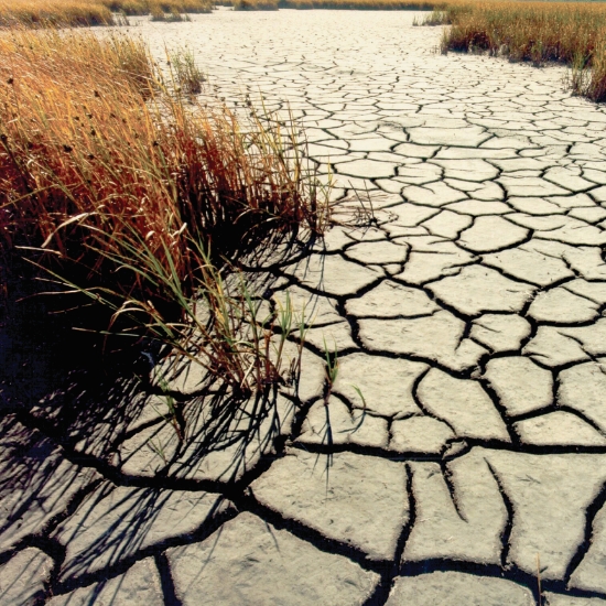
Dry soil
Image credit: USGS
Sea level is rising because melting ice from land is flowing into the ocean and because seawater expands as it warms. Very precise, continuous measurements of sea level heights worldwide began in 1992 with the U.S./French Topex/Poseidon mission, and continue through the Jason series of sea level altimetry missions. Altimeter measurements, however, see only the full effect of ocean height changes from all causes -- that is, the combined impacts of ocean warming, ice melting and runoff from land. To get an in-depth view of the processes responsible for the changes, it is necessary to know how much of the full effect is due to each one.
GRACE observations enable us to distinguish between changes in water mass and changes in ocean temperatures. An example of the value of this ability was a study that documented a sizable -- if temporary -- drop in sea level and linked it to disruptions in the global water cycle from the large 2011 La Niña event. The study showed that the water that evaporated from the warm ocean, causing the drop in sea level, was mostly rained out over Australia, South America and Asia. Australia does not have large river systems leading from the interior to the ocean, so most of the rain that fell there remained there until it evaporated. The finding provided a new view into the dynamics and connections that shape the global water cycle.
Rising seas
Image credit: UN / Milton Grant
Ocean currents distribute heat across the planet, and thus any changes in ocean currents are an important indicator of how our planet is responding and evolving in a warming climate. At the bottom of the atmosphere -- on Earth's surface -- changes in air pressure (a measure of air’s mass) tell us about flowing air, or wind. At the bottom of the ocean, changes in pressure tell us about flowing water, or currents. Felix Landerer and colleagues at JPL developed a way to isolate the signal in GRACE data that indicates tiny pressure variations at the ocean bottom caused by changes in deep ocean currents. The measurements showed a significant, temporary weakening of the Atlantic meridional overturning circulation, a crucial global climate regulator that transports vast amounts of heat from lower to higher latitudes. A network of ocean buoys that spans the Atlantic near 26 degrees north latitude also recorded this drop in the winter of 2009-10, but GRACE enabled the detection of this signal several thousand miles north and south of the buoys' latitude, providing new insights into large-scale ocean current processes. The measurements from GRACE agreed well with estimates from the buoy network, giving the researchers confirmation that the technique can be expanded to provide estimates throughout the Atlantic and beyond.
EARTH, FIRE AND AIR
Although most of GRACE's discoveries have involved water and ice, its data are useful in other areas of Earth science. A recent research project suggested that eventually GRACE soil moisture data might help in forecasting regional wildfire risks. Thus, the satellites' data have now been applied to all four elements of the ancient cosmos -- earth, water, fire and air -- an appropriate indicator of how their use is expanding.
The viscous mantle under Earth's crust is also moving ever so slightly in response to mass changes from water near the surface. NASA scientists used GRACE data to calculate how ice sheet loss and groundwater depletion have actually changed the rotation of Earth as the system adjusts to these movements of mass.
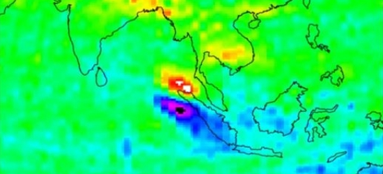
In the early GRACE mission stages, it was not clear if the mission's measurement could be used to detect the changes in mass associated with large earthquakes, because only certain large earthquakes move enough mass for GRACE to detect. But during its 15 years in orbit, GRACE was able to measure the instantaneous mass shifts from several large earthquakes. For the first time, Jeanne Sauber-Rosenberg (NASA GSFC) and collaborators could identify in the GRACE data gravity changes associated with the large but slow tectonic mass adjustments that go on for months or years after an earthquake. These measurements provide unprecedented insights into what is happening far below Earth's surface during and after big quakes such as the 2004 Sumatra event and the 2011 Tohuku (Japan) quake, both of which caused devastating tsunamis.
Large mass shifts on the surface (e.g., from ice melt) can even affect Earth's rotation. Any change in the distribution of mass will cause Earth’s axis to shift, wobble, and readjust like a spinning top. GRACE helps pinpoint those rotation changes and understand their causes.
Earthquake data from GRACE
Image credit: NASA/JPL/University of Texas-CSR
Each satellite, using its GPS receivers and special antennas, makes at least 200 radio occultation observations a day for determining atmospheric temperature and humidity profiles. This is done by measuring how much signals from GPS satellites are distorted by the atmosphere. Forward- and aft-pointing antennas on each satellite measure signals from GPS satellites as they appear to rise or set behind Earth, "looking" horizontally through a thick layer of atmosphere. Water vapor in the atmosphere bends and refracts the GPS signals. By comparing these distorted GPS signals with signals from higher-elevation GPS satellites, which do not pass through so much atmosphere, profiles of temperature and humidity down to an altitude of about 60 miles (100 kilometers) are calculated.
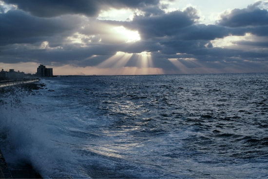
Clouds at dusk
Image credit: UCAR / Carlye Calvin
CONTINUITY IS CRITICAL
Rising sea levels, changing aquifers, floods, droughts and melting ice sheets: it's obvious why researchers want GRACE-FO to continue monitoring these high-impact changes in the Earth system that GRACE first allowed them to quantify.
Continuing mass change measurements will open up new science territory. Rainfall, ocean currents and other processes vary naturally. Many of the processes that GRACE measured, like the melting polar ice sheets, were not quantified before this mission. While 15 years of high-quality, global and nearly uninterrupted data have already produced a plethora of discoveries, the longer data record from GRACE-FO is essential to tease out the signal of long-term climate evolution from the effects of recurring climate patterns. This will allow a better understanding of how climate change, natural climate cycles and natural variability interact.
SCIENCE TEAM
NASA has been funding a competitively selected science team for the GRACE mission, and since 2016, for both the GRACE and GRACE-FO missions. The annual team meetings include scientists from more than 10 countries and were sponsored by the U.S. and GFZ co-principal investigator institutions, alternating the meeting location between Austin, Texas and Potsdam, Germany.

