OVERVIEW

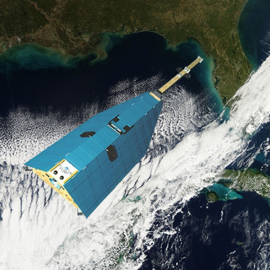
All matter in the Earth system has mass and exerts a gravitational pull, including a pull on orbiting Earth satellites. By precisely measuring changes in Earth's gravity field with regional resolution from month to month, the Gravity Recovery and Climate Experiment Follow-On (GRACE-FO) mission continues the GRACE mission’s critical task of measuring and monitoring the movements of mass within and between Earth’s atmosphere, oceans, land and ice sheets, as well as within Earth itself (such as from large earthquakes and slow changes in Earth’s viscous mantle). These data provide unique insights into Earth’s changing climate, Earth system processes and even the impacts of some human activities. They also have far-reaching benefits to society, such as improving the accuracy of environmental monitoring and forecasts.

GRACE-FO, a partnership between NASA and the German Research Centre for Geosciences (GeoForschungsZentrum, GFZ), extends the 15-plus-year data record of GRACE, which operated from 2002 to 2017, and will demonstrate new technology to potentially improve upon the precision of GRACE’s measurements for future GRACE-like missions. The importance of continuing measurements of mass change was recently highlighted by the National Academy of Sciences in its 2017-2027 Decadal Survey for Earth Science and Applications from Space, released in December 2017. The survey identified measurements of mass change as one of NASA’s five highest-priority Earth observation needs for the next decade and as a foundational element to ensure continuity with both GRACE and GRACE-FO.

Having a time series of measurements of sufficient length, consistency and continuity is vital to determining climate variability and change. Whether or not observed multiyear trends represent long-term changes in mass balance can only be determined by extending the length of the observations. By continuing the essential climate data record established by GRACE, GRACE-FO will provide invaluable observations of long-term climate-related mass changes, such as the ongoing loss of mass of the West Antarctic and Greenland ice sheets, and many other land glaciers, as well as changes in the water cycle and land water storage. Longer records allow climate scientists to separate short-term variability from longer-term trends.

Conceptually nearly identical to the GRACE mission, GRACE-FO consists of two identical satellites flying in formation around Earth at an initial altitude of approximately 305 miles (490 kilometers) and a nominal separation distance of 137 miles (220 kilometers). Instruments on board the satellites precisely measure changes in the distance between them due to orbital perturbations caused by variations in Earth’s gravity field over space and time. By combining these data with precise knowledge of the satellites’ positions as determined by GPS observations, position and orientation of the satellites as measured by star trackers, and non-gravitational forces acting on each satellite as measured by high-precision accelerometers, the distribution of Earth’s mass changes near the surface will be calculated every month and tracked over time.

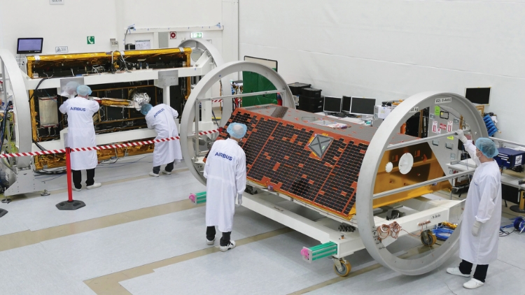
Two satellites in clean room

GRACE Follow-On being built
Image credit: Airbus DS GmbH/A. Ruttloff

GRACE-FO will expand GRACE’s legacy of scientific achievements. These include tracking mass changes in Earth’s polar ice sheets and mountain glaciers (which impact global sea level); estimating total water storage on land (from groundwater changes in deep aquifers to changes in soil moisture and surface water); inferring changes in deep ocean currents, a driving force in climate; and even measuring changes within the solid Earth itself, such as postglacial rebound and the impact of major earthquakes. To date, GRACE observations have been used in more than 4,300 research publications.

GRACE-FO’s primary mission objective is to continue the high-resolution monthly global maps of Earth's gravity field and surface mass changes of the original GRACE mission over a period of five years. The secondary objectives are twofold: first, GRACE-FO will demonstrate the effectiveness of a novel Laser Ranging Interferometer (LRI) in improving satellite-to-satellite tracking measurement performance, laying the groundwork for improved GRACE-like geodetic missions in the future. The LRI will be the first-ever demonstration of laser interferometry in space between satellites. Second, GRACE-FO will measure the structure of Earth’s atmosphere by performing radio occultation measurements of GPS tracking signals, a cost-effective technique to measure vertical atmospheric temperature and humidity profiles by observing how much signals from GPS satellites are distorted as they travel through the atmosphere. The sounding process will provide 200 to 250 vital profiles of atmospheric temperature and water vapor content per satellite each day to aid weather forecasting. GPS Radio Occultation (GPSRO) data from GRACE were provided to U.S. and European weather prediction centers for use in weather forecasting products.

As on GRACE, NASA is partnering with Germany on GRACE-FO to provide continuity with the GRACE measurements. While for continuity the baseline science and performance requirements are the same, the GRACE-FO mission implements improvements based on lessons learned from GRACE. Design changes were limited to those that were required to meet the recommendations of the GRACE Science Study Team, to use the current-generation satellite bus, to resolve hardware obsolescence issues and to accommodate the Laser Ranging Interferometer as a technology demonstration.

WHAT GRACE-FO WILL DO

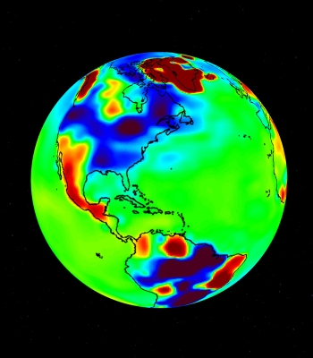
Gravity map of Earth.

GRACE gravity map
Image credit: NASA/JPL-Caltech

Over its five-year lifetime, GRACE-FO will:


  • Provide monthly maps of how gravity changes are distributed on Earth to precisely track variations in ice mass, total water storage on land (from deep aquifers to soil moisture and surface water), sea level and ocean circulation, as well as some solid Earth processes, including postglacial rebound and major earthquakes.
  • Obtain accurate global and high-resolution models for the static (i.e., non-changing) component of Earth’s gravity field to support other geodetic missions such as satellite altimetry over the oceans.
  • Provide 200 to 250 profiles of atmospheric temperature and water vapor content every day per satellite.

BRIEF PROGRAM HISTORY

The CHAMP satellite. Image credit: NASA

The CHAMP Satellite
Image credit: NASA

The concept for using satellite-to-satellite tracking to determine a planetary gravity field dates back to the late 1960s. In 1997, NASA selected the GRACE mission under its Earth System Science Pathfinder program to use this technique to resolve the time-varying gravity field of Earth.

GRACE built on the heritage of a predecessor mission called the Challenging Minisatellite Payload (CHAMP). Built by Dornier Satellitensysteme, managed by the German Research Centre for Geosciences (GFZ) and launched in July 2000, CHAMP’s instruments and its orbit allowed it to generate simultaneous, highly precise measurements of Earth’s gravitational and magnetic fields. It measured how both fields vary across Earth’s surface as well as how they change with time. In addition, CHAMP tested the use of GPS instruments flown in low-Earth orbit to study Earth’s atmosphere and ionosphere, with potential applications in weather prediction and weather monitoring from space.

While CHAMP significantly advanced the field of geodesy, scientists had long desired an even more advanced mission based on dual satellites flying in formation to improve CHAMP’s relatively low resolution. The unique design of the GRACE mission dramatically improved existing gravity maps and allowed much-improved resolution of the broad- to finer-scale features of Earth’s gravitational field over both land and sea. It also showed how much Earth’s gravitational field varies over time. Before GRACE, current models of the static geoid were accurate from 20 to 90 centimeters at horizontal scales of 180 miles (300 kilometers). GRACE improved these numbers to the sub-centimeter level.

GRACE, a competitively selected principal investigator mission led by Principal Investigator Byron Tapley of the University of Texas at Austin Center for Space Research (UT-CSR) and Co-Principal Investigator Christoph Reigber (later followed by Frank Flechtner in 2009) of GFZ, was a joint mission between NASA and the Deutsches Zentrum für Luft- und Raumfahrt (DLR) in Germany. The original NASA project scientist was Mike Watkins of NASA’s Jet Propulsion Laboratory (later followed by JPL’s Carmen Boening in 2015). Watkins, a former student of Tapley’s, was instrumental in the development of GRACE’s proposal to NASA. Tapley was directly responsible to NASA for the success of the mission, including developing the flight mission hardware, accomplishing the scientific objectives, and delivering the data products to the broader Earth science community and general public. Tapley delegated day-to-day project management and implementation authority for the mission to JPL.

GRACE was launched on March 17, 2002, from Plesetsk Cosmodrome, Russia, on a planned five-year mission. Its science mission concluded in October 2017 after more than 15 years of successful operations, with GRACE-B re-entering the atmosphere in December 2017 and GRACE-A in March 2018.

In June 2010, NASA identified development of GRACE-FO as one of the “Climate Continuity Missions” in its NASA Climate Architecture report. Development of GRACE-FO subsequently began in 2012.


NASA/GERMAN COLLABORATION

GRACE-FO will continue a highly successful partnership between NASA and Germany. The original GRACE mission was a joint project between NASA and DLR. GRACE ground segment operations were co-funded by GFZ, DLR and the European Space Agency.

GRACE-FO is a partnership between NASA and GFZ, with participation by DLR.

NASA is responsible for overall mission management, with project management assigned to JPL. JPL is responsible for the twin satellites, built by Airbus Defence and Space in Germany under contract to JPL. JPL is also responsible for the accelerometer, built by ONERA in France, the microwave instrument, the electronics portion of the Laser Ranging Interferometer, and U.S. science processing and science distribution.

GFZ is responsible for European science and science processing (jointly with JPL), mission operations, optical components of the Laser Ranging Interferometer, the Laser Retro-Reflectors, and launch services (contracted to Iridium for a rideshare on a SpaceX Falcon 9 rocket), with support from Bundesministerium für Bildung und Forschung (BMBF), Bundesministerium für Wirtschaft und Energie (BMWi), Helmholtz Association of German Research Centres (HGF), Albert Einstein Institute/Max Planck Institute for Gravitational Physics (AEI) and DLR. GFZ has subcontracted mission operations to DLR, which operates the German Space Operations Center, providing the support and infrastructure needed to operate the GRACE-FO satellites.

BACK TO TOP