OVERVIEW

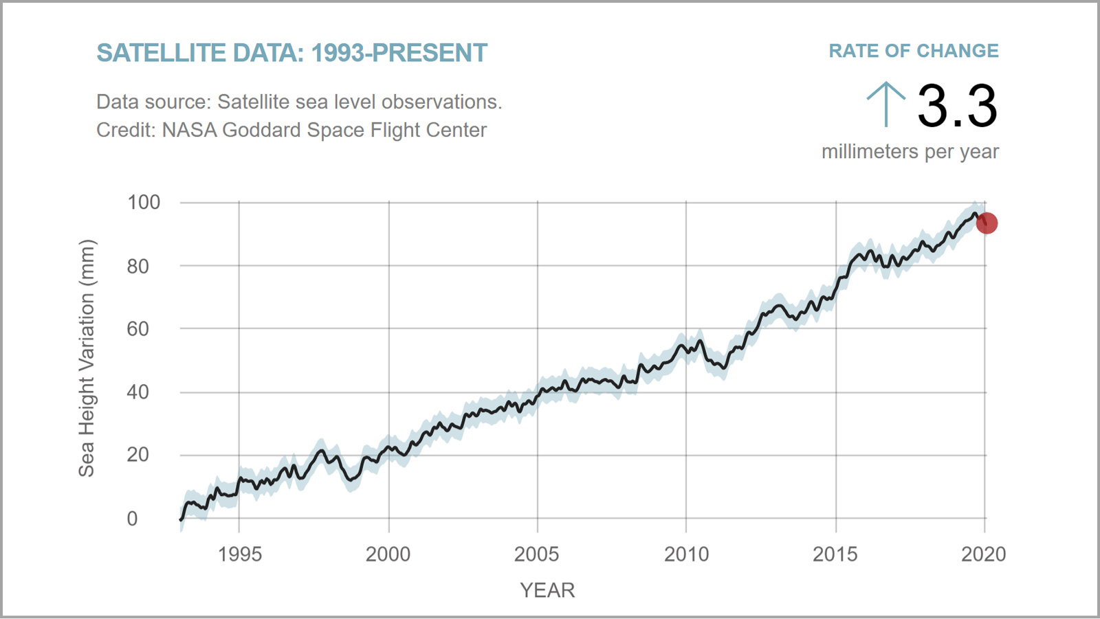
Earth's climate is changing. To understand what that means for the planet and for humanity, scientists need a long view. For nearly 30 years, an uninterrupted series of satellites has circled Earth, keeping an eye on one of the clearest signals of global warming – sea level rise. The Sentinel-6 Michael Freilich satellite and a second identical satellite, both part of a joint U.S.-European effort, will add another 10 years of sea level measurements to that dataset. Sentinel-6 Michael Freilich was named for the former director of NASA's Earth Science Division, who substantially contributed to the mission's realization.

The two identical spacecraft, launched five years apart, will study ocean heights from an orbit 830 miles (1,336 kilometers) above the planet's surface. Sentinel-6 Michael Freilich has a prime mission of 5.5 years and will launch no earlier than Nov. 10. Its doppelganger, Sentinel-6B, will lift off in 2025. Along with measuring global sea level rise and ocean circulation, the satellites will record vertical profiles of atmospheric temperature and humidity. The data will help scientists to forecast how much the ocean could encroach on coastlines, improve weather forecasts and hurricane predictions, and advance the study of ocean tides and phenomena like El Niño and La Niña.

Both satellites will follow in the flight path of four previous U.S.-European missions focused on ocean heights. The first, TOPEX/Poseidon, launched in 1992. It was followed in 2001 by Jason-1, then OSTM/Jason-2 in 2008, and then by the still-operational Jason-3 in 2016. Like the others, Jason-3 flies in the same orbit as its predecessor and was launched before the previous one was decommissioned. This approach has allowed scientists and engineers to cross-calibrate the data that the satellites collect to ensure the continuity of measurements from one mission to the next.

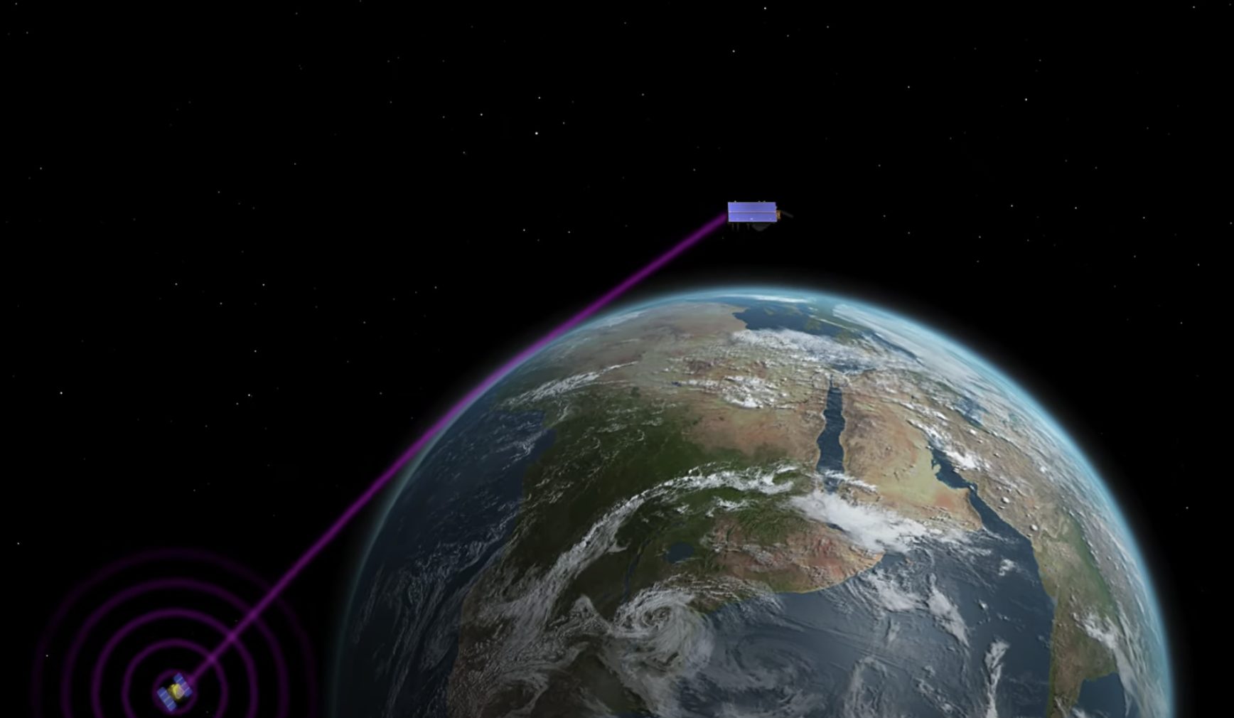
When Sentinel-6 Michael Freilich reaches orbit, it will fly about 30 seconds behind the Jason-3 satellite. Scientists and engineers will spend about a year cross-calibrating the data collected by the two spacecraft. Following this, Jason-3 will be moved into a complementary interleaved orbit and Sentinel-6 Michael Freilich will take over the role of providing primary measurements. Then, in 2025, engineers will perform the same cross-calibration with Sentinel-6B as Sentinel-6 Michael Freilich's prime mission winds down.

The Sentinel-6/Jason-CS mission is being jointly developed by ESA (the European Space Agency), the European Organisation for the Exploitation of Meteorological Satellites (EUMETSAT), NASA, and the National Oceanic and Atmospheric Administration (NOAA), with funding support from the European Commission and support from France's National Centre for Space Studies (CNES).

WHAT'S UP WITH SEA LEVEL?

Measuring the height of the ocean gives scientists a real-time indication of how Earth's climate is changing. The oceans absorb more than 90% of the excess heat from the planet's warming climate. Seawater expands as it heats up, resulting in about a third of the modern-day global average sea level rise. Melting ice from glaciers and ice sheets accounts for the rest.

Currently, sea levels rise at a rate of over 0.13 inches (3.3 millimeters) per year, more than twice the rate at the start of the 20th century. Knowing how this rate is changing gives climate scientists an idea of how rising seas will encroach on coastlines around the world.

Like its predecessors, Sentinel-6 Michael Freilich will measure sea level by bouncing electromagnetic signals off the ocean's surface and measuring the time it takes for the pulses to return. The satellite's high-resolution capabilities also mean that scientists will be able to monitor the ocean closer to the coasts than they could with previous sea level missions. Researchers will be able to track features, including small coastal currents and eddies that pinch off of larger currents such as the Gulf Stream.

Because eddies that break off the Gulf Stream can be several degrees warmer than the surrounding ocean, tracking them can be especially important for monitoring hurricanes. These storms run on warm seawater, and the warmer the water, the more fuel is available to supercharge them.

The Sentinel-6 Michael Freilich satellite will also give climate researchers a better understanding of phenomena like El Niño and its counterpart, La Niña. Triggered by a huge fluctuation in the winds that normally blow from east to west across the equatorial Pacific Ocean, El Niño can shift ocean currents and global weather patterns, bringing torrential rain to the Southwestern U.S. and triggering droughts in Asia and Australia. La Niña can have the opposite effect.

One prior discovery to come out of the existing sea level dataset that the mission will extend is the far-reaching effects of these weather phenomena. So much seawater evaporated and formed rain clouds during a massive La Niña in 2010 that it flooded huge parts of Australia and Southeast Asia, and temporarily dropped global sea levels by 0.4 inches (1 centimeter). Before then, scientists had no idea that these weather systems could have such an outsized, short-term impact on global sea levels.

This chart shows the rise in global average sea level from January 1993 to January 2020 as measured by satellite missions.
Image credit: NASA Goddard Space Flight Center

A BIRD'S-EYE VIEW OF THE ATMOSPHERE

A secondary science objective of Sentinel-6 Michael Freilich is to gather vertical profiles of atmospheric temperature and humidity. The instrument responsible for these measurements, the Global Navigation Satellite System - Radio Occultation (GNSS-RO) sensor, can see down through Earth's atmosphere to within 1,600 feet (500 meters) of the surface, even through heavy rain and thick clouds.

Temperature and humidity drive what happens in the planet's atmosphere, shaping weather patterns and the formation of storms. Advancing the accuracy of information that scientists collect on these aspects of the atmosphere is key to improving forecasts.

Meteorologists feed data, including air temperature, humidity, and wind speed and direction into computer models to formulate their weather forecasts. The information comes from a variety of sources, including satellite-based radiometers, weather balloons, and instruments aboard commercial airliners. But each platform can have its limitations. In some cases, researchers may need to compensate for biases in the data: For example, air temperature readings from a thermometer on an airplane can be influenced by its immediate surroundings.

Data from the GNSS-RO doesn't have these constraints. The instrument on Sentinel-6 Michael Freilich will provide globally-distributed vertical profiles, and its data won't be biased by things such as proximity to airplane fuselages. Meteorologists will be able to include accurate atmospheric temperature and humidity data into their models within three hours after Sentinel-6 Michael Freilich collects it. They will also be able to use that information as a reference point for correcting data from other similar atmospheric instruments.

The GNSS-RO instrument derives its measurements by analyzing radio signals from global navigation satellites. As these radio signals travel through different layers of Earth's atmosphere, they bend and slow down by varying degrees. The GNSS-RO measures these changes, and researchers can then derive atmospheric characteristics such as temperature and humidity at different altitudes. The technology in this instrument was developed at JPL and has been included on other satellite missions.

Sentinel-6 Michael Freilich will also carry an instrument that will track radio signals from orbiting navigation satellites to measure the physical properties of the atmosphere.
Image credit: NASA/JPL-Caltech

BACK TO TOP