
WHAT IS JTRF?
About
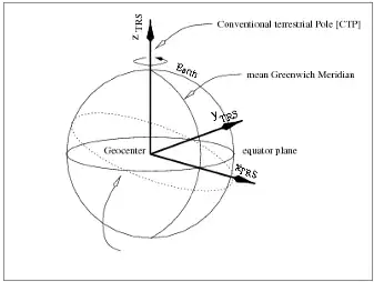
What is a Terrestrial Reference Frame?
The definition of a Terrestrial Reference Frame (TRF) is foundational for virtually all space-based and ground-based Earth observation programs. The positions of objects are determined in relation to an underlying TRF and the accuracy with which such objects can be georeferenced ultimately depends upon the intrinsic frame accuracy. Terrestrial (and celestial) reference frames determined by space-geodetic (SG) observing systems provide the universal standard against which the Earth’s changing shape, and its rotation are measured and represent the tool through which space- and ground-based Earth observations can be connected in space and in time.
The International Terrestrial Reference Frame
The international standard TRF is the International Terrestrial Reference Frame (ITRF). The ITRF is accurate and precise enough to support even applications with the most demanding requirements for positioning. The ITRF is a product of the International Association of Geodesy (IAG). The IAG’s International DORIS Service (IDS), International GNSS Service (IGS), International Laser Ranging Service (ILRS), and International VLBI Service for Geodesy and Astrometry (IVS) provide precise positions of ground stations of their respective Networks of stations. The IAG International Earth Rotation and Reference Systems Service (IERS) then combines the Network station positions, augmented with other data, to produce the ITRF and makes it available to the international community to ensure consistency and interoperability of positioning systems.

About JPL Terrestrial Reference Frame (JTRF)
The JPL Terrestrial Reference Frame is a Terrestrial Reference Frame Combination Center (TRF CC) as a part of the JPL Space Geodesy Task (JSGT). It uses data and analysis products from all geodetic techniques to produce and provide a high-quality combined terrestrial reference frame (TRF) and other products to support NASA’s missions and science. The TRF CC also supports the International Earth Rotation and Reference Systems Service (IERS) by providing candidate solutions for the International Terrestrial Reference Frame (ITRF) and assessing the quality of candidate solutions from other institutions.
Outreach and Education Resources
To learn more about geodesy and reference frames, see the following resources below.
- 9 Impacts of Geodesy [UNAVCO]
- UNAVCO Posters & Graphics on Geodesy
- CDDIS - NASA's Archive of Space Geodesy Data
- Earth Orientation Animations [NASA GSFC SGP]
- "On Target With GPS" [NASA GSFC SGP]
- "SLR Pi Day Podcast" [NASA GSFC SGP]
- "Using Quasars to Measure the Earth: A History of VLBI" [NASA GSFC SGP]
Software Resources
Below you will find a list of helpful software to obtain JTRF solution data:
- GipsyX – developed by the Jet Propulsion Laboratory (JPL), and maintained by the Near Earth Tracking Applications and Systems groups. It replaces the GIPSY-OASIS (GNSS-Inferred Positioning System and Orbit Analysis Simulation Software) software.
Acknowledgements
This work was carried out at the Jet Propulsion Laboratory, California Institute of Technology, under a contract with the National Aeronautics and Space Administration (NASA).
We thankfully acknowledge funding support from NASA’s Space Geodesy Program.