InSight's purpose is to study the interior of Mars, not the surface. Still, location matters. The landing site, a smooth expanse of lava plans called Elysium Planitia, was carefully selected for its safety and sunlight, among other attributes.
The camera on InSight's arm will take images to make a 360-degree panorama of the surroundings after landing. The panorama is expected to look much the same in all directions: flat, no big hills nearby and few large rocks in view. That expectation is based on many high-resolution images taken from orbit, as the site was evaluated.
The site lies in the western portion of Elysium Planitia, centered at about 4.5 degrees north latitude and 135.9 degrees east longitude. The spacecraft has a better than 99 percent chance of coming down within a "landing ellipse" surrounding the targeted center of the site. InSight's landing ellipse is about 81 miles (130 kilometers) west-to-east and about 17 miles (27 kilometers) north-to-south.
Planitia is Latin for a flat surface, geometric plane or geographical plain. Elysium is from the ancient Greek name for an afterlife paradise, usually referred to in English as the Elysian Fields.
InSight has several very specific requirements for its landing location. One is being close enough to the equator for the lander's solar array to have adequate power at all times of the year, and another is to have the right conditions for keeping the spacecraft's electronics warm. That combination constrains eligible sites to a band just north of the equator, between 5 degrees north latitude and 3 degrees north latitude.
Also, the elevation must be low enough to have sufficient atmosphere above the site for a safe landing, because the spacecraft will rely on the atmosphere for deceleration with a parachute during descent. The safety criterion for elevation of the site is at least 8,200 feet (2.5 kilometers) lower than a reference zero elevation that is used as Mars' equivalent of "sea level."
Only three areas on Mars meet these basic engineering constraints for InSight. Besides Elysium Planitia, the only other two areas are Isidis Planitia and Valles Marineris.
The Context Camera (CTX) and High Resolution Imaging Science Experiment (HiRISE) cameras on NASA's Mars Reconnaissance Orbiter played important roles in evaluating candidate landing sites on Mars. HiRISE images revealed individual rocks down to the size of about 3 feet (1 meter) across and CTX images provided regional context. Stereo pairs of images provided three-dimensional information used for evaluating the steepness of slopes. HiRISE took about 150 images of candidate InSight landing sites.
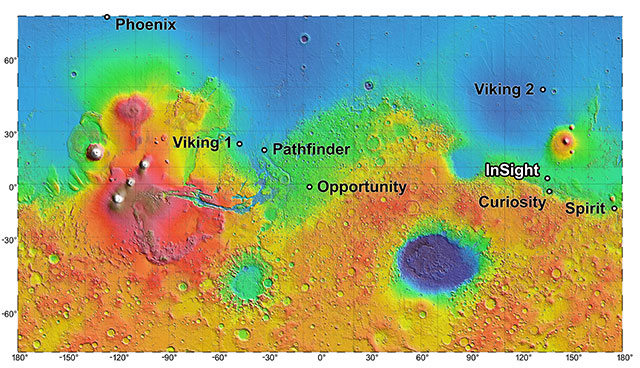
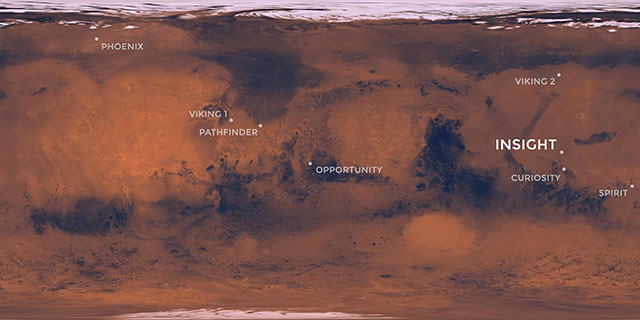
The landing site for InSight, in relation to landing sites for seven previous missions, is shown on a topographic map of Mars. Download image
Rockiness and slope are factors in landing safety and are also important in determining whether InSight can succeed in its mission after landing. An overly steep nearby slope could foil the robotic arm's access to a sufficiently large work area beside the lander. A steep slope in the wrong direction could jeopardize adequate power output from the solar arrays. A large enough rock at the landing site could block one of the solar arrays from opening. Rocks and steep slopes could also prevent placing the seismometer and heat-flow probe on the surface.
Isidis Planitia and Valles Marineris were assessed as too rocky and windy. Valles Marineris also lacks any swath of flat ground large enough for a safe landing. That left Elysium. For the first time ever, the site evaluation for this Mars mission also extended beneath the ground surface. For mission success, the ground in the lander's workspace must be penetrable by InSight's heat-flow probe. The probe was designed to hammer itself into the soil to a depth 10 to 16 feet (3 to 5 meters).
Key evidence showing that the ground in Elysium will be loose material suitable for burrowing, rather than solid bedrock, came from an assessment by the Thermal Imaging System (THEMIS) on NASA's Mars Odyssey orbiter. Observations by this camera show how quickly the ground cools at night or warms in sunlight. (Solid rock changes temperature more slowly than softer ground.)
In workshops in 2013, 2014 and 2015, an initial list of 22 candidate landing ellipses in Elysium was narrowed to four finalists. The final site was judged to be the safest and most likely to lead to mission success.
Elevation within the selected ellipse averages about 8,700 feet (2,650 meters) lower than the reference zero elevation.
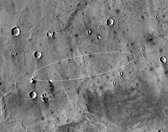
Smooth, flat ground dominates InSight's landing ellipse in the Elysium Planitia region of Mars. The ellipse is about 81 miles (130 kilometers) long, generally west to east, and about 17 miles (27 kilometers) wide, covering the area where the spacecraft has about 99 percent chance of landing. The base map is a mosaic of thermal infrared images from the Thermal Emission Imaging System (THEMIS) camera on NASA's Mars Odyssey orbiter. Thermal images can be used to infer surface properties. For example, the dark halos around small craters indicate rocky material ejected from them. The ellipse shown here is for launch on the first possible date: May 5, 2018. For launches later during the five-week launch period, the ellipse rotates clockwise, to about 12 degrees of rotation for launch at the latest opportunity. Download image